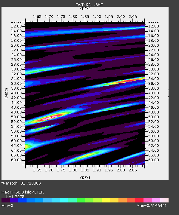
T40A Mansfield, MO, USA - Earthquake Result Viewer
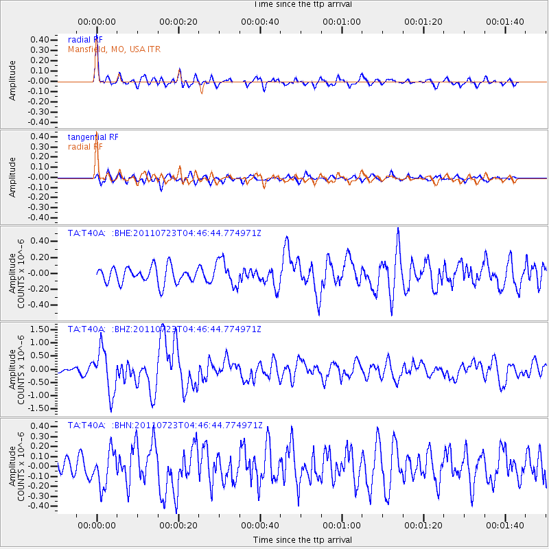
Earthquake location: Near East Coast Of Honshu, Japan
Earthquake latitude/longitude: 38.9/141.8
Earthquake time(UTC): 2011/07/23 (204) 04:34:24 GMT
Earthquake Depth: 41 km
Earthquake Magnitude: 5.9 MB, 5.9 MS, 6.4 MW, 6.3 MW
Earthquake Catalog/Contributor: WHDF/NEIC
Network: TA USArray Transportable Network (new EarthScope stations)
Station: T40A Mansfield, MO, USA
Lat/Lon: 37.15 N/92.52 W
Elevation: 399 m
Distance: 89.3 deg
Az: 40.48 deg
Baz: 320.654 deg
Ray Param: 0.041905314
Estimated Moho Depth: 50.0 km
Estimated Crust Vp/Vs: 1.71
Assumed Crust Vp: 6.53 km/s
Estimated Crust Vs: 3.825 km/s
Estimated Crust Poisson's Ratio: 0.24
Radial Match: 81.728386 %
Radial Bump: 400
Transverse Match: 71.044525 %
Transverse Bump: 400
SOD ConfigId: 405110
Insert Time: 2011-12-29 05:13:31.211 +0000
GWidth: 2.5
Max Bumps: 400
Tol: 0.001

Signal To Noise

ChannelStoNSTALTA
TA:T40A: :BHZ:20110723T04:46:44.774971Z7.91257868.433788E-71.065871E-7
TA:T40A: :BHN:20110723T04:46:44.774971Z1.17601511.8212893E-71.5486954E-7
TA:T40A: :BHE:20110723T04:46:44.774971Z1.64257111.6554944E-71.0078677E-7
Arrivals
Ps5.5 SECOND
PpPs20 SECOND
PsPs/PpSs26 SECOND