You are here: Home > Network List > TA - USArray Transportable Network (new EarthScope stations) Stations List
> Station W40A Ferguson Farm, Pottsville, AR, USA > Earthquake Result Viewer
W40A Ferguson Farm, Pottsville, AR, USA - Earthquake Result Viewer
| Earthquake location: |
Near East Coast Of Honshu, Japan |
| Earthquake latitude/longitude: |
38.9/141.8 |
| Earthquake time(UTC): |
2011/07/23 (204) 04:34:24 GMT |
| Earthquake Depth: |
41 km |
| Earthquake Magnitude: |
5.9 MB, 5.9 MS, 6.4 MW, 6.3 MW |
| Earthquake Catalog/Contributor: |
WHDF/NEIC |
|
| Network: |
TA USArray Transportable Network (new EarthScope stations) |
| Station: |
W40A Ferguson Farm, Pottsville, AR, USA |
| Lat/Lon: |
35.19 N/93.07 W |
| Elevation: |
108 m |
|
| Distance: |
90.5 deg |
| Az: |
42.067 deg |
| Baz: |
320.333 deg |
| Ray Param: |
0.041662794 |
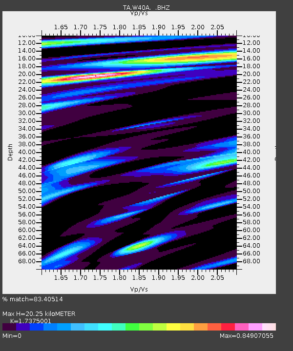
| Estimated Moho Depth: |
20.25 km |
| Estimated Crust Vp/Vs: |
1.74 |
| Assumed Crust Vp: |
6.498 km/s |
| Estimated Crust Vs: |
3.74 km/s |
| Estimated Crust Poisson's Ratio: |
0.25 |
|
| Radial Match: |
83.40514 % |
| Radial Bump: |
400 |
| Transverse Match: |
82.967804 % |
| Transverse Bump: |
400 |
| SOD ConfigId: |
405110 |
| Insert Time: |
2011-12-29 05:13:55.135 +0000 |
| GWidth: |
2.5 |
| Max Bumps: |
400 |
| Tol: |
0.001 |
|
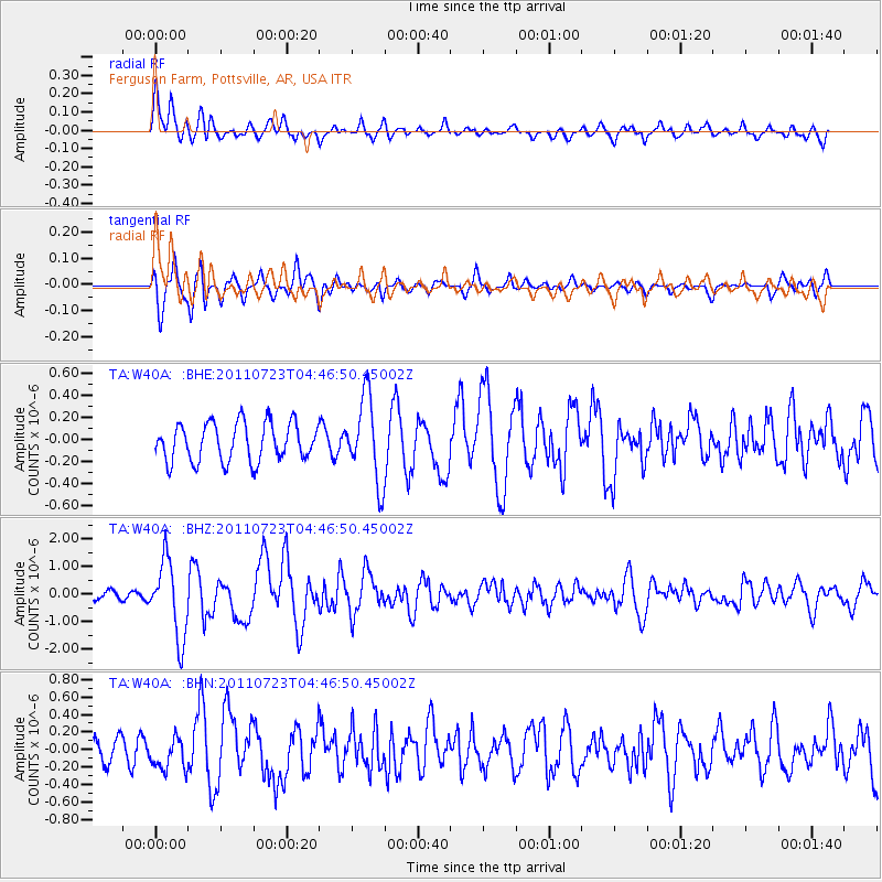
Signal To Noise
| Channel | StoN | STA | LTA |
| TA:W40A: :BHZ:20110723T04:46:50.45002Z | 6.6483083 | 1.3811538E-6 | 2.0774515E-7 |
| TA:W40A: :BHN:20110723T04:46:50.45002Z | 1.5120729 | 1.8251299E-7 | 1.2070383E-7 |
| TA:W40A: :BHE:20110723T04:46:50.45002Z | 2.1902633 | 3.7959623E-7 | 1.7331077E-7 |
| Arrivals |
| Ps | 2.3 SECOND |
| PpPs | 8.3 SECOND |
| PsPs/PpSs | 11 SECOND |


