You are here: Home > Network List > LD - Lamont-Doherty Cooperative Seismographic Network Stations List
> Station MVL Millersville University, PA > Earthquake Result Viewer
MVL Millersville University, PA - Earthquake Result Viewer
| Earthquake location: |
Near Coast Of Northern Chile |
| Earthquake latitude/longitude: |
-19.6/-70.8 |
| Earthquake time(UTC): |
2014/04/01 (091) 23:46:46 GMT |
| Earthquake Depth: |
20 km |
| Earthquake Magnitude: |
8.2 MWW, 8.0 MI, 8.1 MWC |
| Earthquake Catalog/Contributor: |
NEIC PDE/NEIC COMCAT |
|
| Network: |
LD Lamont-Doherty Cooperative Seismographic Network |
| Station: |
MVL Millersville University, PA |
| Lat/Lon: |
40.00 N/76.35 W |
| Elevation: |
91 m |
|
| Distance: |
59.6 deg |
| Az: |
355.071 deg |
| Baz: |
173.949 deg |
| Ray Param: |
0.06208806 |
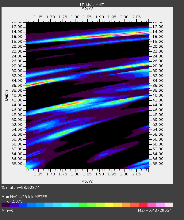
| Estimated Moho Depth: |
14.25 km |
| Estimated Crust Vp/Vs: |
2.08 |
| Assumed Crust Vp: |
6.419 km/s |
| Estimated Crust Vs: |
3.094 km/s |
| Estimated Crust Poisson's Ratio: |
0.35 |
|
| Radial Match: |
98.92874 % |
| Radial Bump: |
219 |
| Transverse Match: |
97.97124 % |
| Transverse Bump: |
327 |
| SOD ConfigId: |
3390531 |
| Insert Time: |
2019-04-10 23:35:39.838 +0000 |
| GWidth: |
2.5 |
| Max Bumps: |
400 |
| Tol: |
0.001 |
|
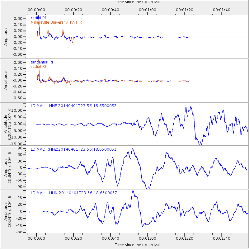
Signal To Noise
| Channel | StoN | STA | LTA |
| LD:MVL: :HHZ:20140401T23:56:18.650005Z | 4.378921 | 2.1554754E-6 | 4.922389E-7 |
| LD:MVL: :HHN:20140401T23:56:18.650005Z | 2.2822273 | 1.046363E-6 | 4.5848324E-7 |
| LD:MVL: :HHE:20140401T23:56:18.650005Z | 2.0713985 | 6.5528934E-7 | 3.163512E-7 |
| Arrivals |
| Ps | 2.5 SECOND |
| PpPs | 6.6 SECOND |
| PsPs/PpSs | 9.0 SECOND |


