You are here: Home > Network List > TA - USArray Transportable Network (new EarthScope stations) Stations List
> Station O42A Bath, IL, USA > Earthquake Result Viewer
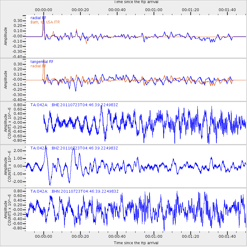
O42A Bath, IL, USA - Earthquake Result Viewer
*The percent match for this event was below the threshold and hence no stack was calculated.
| Earthquake location: |
Near East Coast Of Honshu, Japan |
| Earthquake latitude/longitude: |
38.9/141.8 |
| Earthquake time(UTC): |
2011/07/23 (204) 04:34:24 GMT |
| Earthquake Depth: |
41 km |
| Earthquake Magnitude: |
5.9 MB, 5.9 MS, 6.4 MW, 6.3 MW |
| Earthquake Catalog/Contributor: |
WHDF/NEIC |
|
| Network: |
TA USArray Transportable Network (new EarthScope stations) |
| Station: |
O42A Bath, IL, USA |
| Lat/Lon: |
40.20 N/90.08 W |
| Elevation: |
155 m |
|
| Distance: |
88.1 deg |
| Az: |
37.09 deg |
| Baz: |
322.094 deg |
| Ray Param: |
$rayparam |
*The percent match for this event was below the threshold and hence was not used in the summary stack. |
|
| Radial Match: |
75.086075 % |
| Radial Bump: |
400 |
| Transverse Match: |
72.30184 % |
| Transverse Bump: |
400 |
| SOD ConfigId: |
405110 |
| Insert Time: |
2011-12-29 05:22:11.277 +0000 |
| GWidth: |
2.5 |
| Max Bumps: |
400 |
| Tol: |
0.001 |
|
Signal To Noise
| Channel | StoN | STA | LTA |
| TA:O42A: :BHZ:20110723T04:46:39.224983Z | 7.6357307 | 1.4475725E-6 | 1.8957878E-7 |
| TA:O42A: :BHN:20110723T04:46:39.224983Z | 2.194769 | 3.3039117E-7 | 1.5053575E-7 |
| TA:O42A: :BHE:20110723T04:46:39.224983Z | 2.2398174 | 4.407226E-7 | 1.9676719E-7 |
| Arrivals |
| Ps | |
| PpPs | |
| PsPs/PpSs | |


