You are here: Home > Network List > TA - USArray Transportable Network (new EarthScope stations) Stations List
> Station S41A Jillco Farms, Salem, MO, USA > Earthquake Result Viewer
S41A Jillco Farms, Salem, MO, USA - Earthquake Result Viewer
| Earthquake location: |
Near East Coast Of Honshu, Japan |
| Earthquake latitude/longitude: |
38.9/141.8 |
| Earthquake time(UTC): |
2011/07/23 (204) 04:34:24 GMT |
| Earthquake Depth: |
41 km |
| Earthquake Magnitude: |
5.9 MB, 5.9 MS, 6.4 MW, 6.3 MW |
| Earthquake Catalog/Contributor: |
WHDF/NEIC |
|
| Network: |
TA USArray Transportable Network (new EarthScope stations) |
| Station: |
S41A Jillco Farms, Salem, MO, USA |
| Lat/Lon: |
37.59 N/91.75 W |
| Elevation: |
376 m |
|
| Distance: |
89.3 deg |
| Az: |
39.727 deg |
| Baz: |
321.112 deg |
| Ray Param: |
0.04186882 |
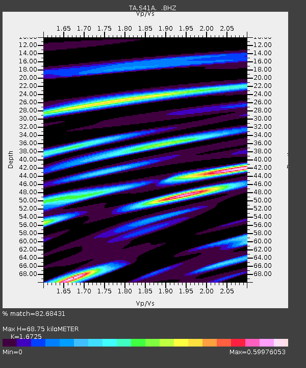
| Estimated Moho Depth: |
68.75 km |
| Estimated Crust Vp/Vs: |
1.67 |
| Assumed Crust Vp: |
6.53 km/s |
| Estimated Crust Vs: |
3.905 km/s |
| Estimated Crust Poisson's Ratio: |
0.22 |
|
| Radial Match: |
82.68431 % |
| Radial Bump: |
400 |
| Transverse Match: |
64.310165 % |
| Transverse Bump: |
400 |
| SOD ConfigId: |
405110 |
| Insert Time: |
2011-12-29 05:22:37.217 +0000 |
| GWidth: |
2.5 |
| Max Bumps: |
400 |
| Tol: |
0.001 |
|

Signal To Noise
| Channel | StoN | STA | LTA |
| TA:S41A: :BHZ:20110723T04:46:45.024971Z | 9.904168 | 9.699276E-7 | 9.7931256E-8 |
| TA:S41A: :BHN:20110723T04:46:45.024971Z | 4.0486383 | 2.519226E-7 | 6.222403E-8 |
| TA:S41A: :BHE:20110723T04:46:45.024971Z | 1.8098518 | 2.0971166E-7 | 1.1587228E-7 |
| Arrivals |
| Ps | 7.2 SECOND |
| PpPs | 27 SECOND |
| PsPs/PpSs | 35 SECOND |


