U42A Revenden, AR, USA - Earthquake Result Viewer
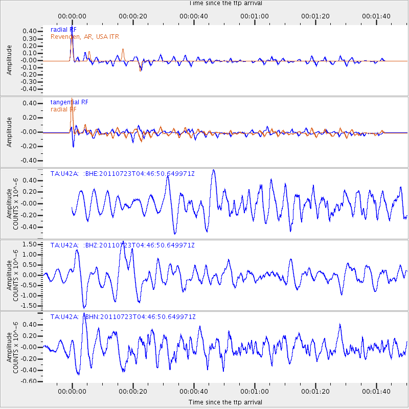
Earthquake location: Near East Coast Of Honshu, Japan
Earthquake latitude/longitude: 38.9/141.8
Earthquake time(UTC): 2011/07/23 (204) 04:34:24 GMT
Earthquake Depth: 41 km
Earthquake Magnitude: 5.9 MB, 5.9 MS, 6.4 MW, 6.3 MW
Earthquake Catalog/Contributor: WHDF/NEIC
Network: TA USArray Transportable Network (new EarthScope stations)
Station: U42A Revenden, AR, USA
Lat/Lon: 36.35 N/91.24 W
Elevation: 119 m
Distance: 90.5 deg
Az: 40.182 deg
Baz: 321.416 deg
Ray Param: 0.04165977
Estimated Moho Depth: 52.75 km
Estimated Crust Vp/Vs: 1.64
Assumed Crust Vp: 6.53 km/s
Estimated Crust Vs: 3.982 km/s
Estimated Crust Poisson's Ratio: 0.20
Radial Match: 80.743126 %
Radial Bump: 387
Transverse Match: 57.35408 %
Transverse Bump: 400
SOD ConfigId: 405110
Insert Time: 2011-12-29 05:22:53.748 +0000
GWidth: 2.5
Max Bumps: 400
Tol: 0.001

Signal To Noise

ChannelStoNSTALTA
TA:U42A: :BHZ:20110723T04:46:50.649971Z6.1430759.210469E-71.4993255E-7
TA:U42A: :BHN:20110723T04:46:50.649971Z3.68377953.3704032E-79.149308E-8
TA:U42A: :BHE:20110723T04:46:50.649971Z2.2777023.0445057E-71.3366568E-7
Arrivals
Ps5.3 SECOND
PpPs21 SECOND
PsPs/PpSs26 SECOND