You are here: Home > Network List > G - GEOSCOPE Stations List
> Station CAN Canberra, Australia > Earthquake Result Viewer
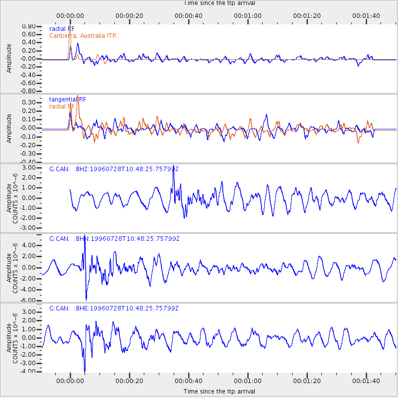
CAN Canberra, Australia - Earthquake Result Viewer
*The percent match for this event was below the threshold and hence no stack was calculated.
| Earthquake location: |
Minahassa Peninsula, Sulawesi |
| Earthquake latitude/longitude: |
1.0/120.2 |
| Earthquake time(UTC): |
1996/07/28 (210) 10:40:43 GMT |
| Earthquake Depth: |
33 km |
| Earthquake Magnitude: |
5.5 MB, 5.5 MS, 6.0 UNKNOWN, 5.9 MW |
| Earthquake Catalog/Contributor: |
WHDF/NEIC |
|
| Network: |
G GEOSCOPE |
| Station: |
CAN Canberra, Australia |
| Lat/Lon: |
35.32 S/149.00 E |
| Elevation: |
650 m |
|
| Distance: |
45.1 deg |
| Az: |
146.175 deg |
| Baz: |
317.108 deg |
| Ray Param: |
$rayparam |
*The percent match for this event was below the threshold and hence was not used in the summary stack. |
|
| Radial Match: |
60.57259 % |
| Radial Bump: |
375 |
| Transverse Match: |
55.471874 % |
| Transverse Bump: |
366 |
| SOD ConfigId: |
4480 |
| Insert Time: |
2010-02-26 21:48:47.724 +0000 |
| GWidth: |
2.5 |
| Max Bumps: |
400 |
| Tol: |
0.001 |
|
Signal To Noise
| Channel | StoN | STA | LTA |
| G:CAN: :BHN:19960728T10:48:25.75799Z | 2.0612876 | 1.3086952E-6 | 6.348921E-7 |
| G:CAN: :BHE:19960728T10:48:25.75799Z | 1.8980051 | 1.0616031E-6 | 5.593257E-7 |
| G:CAN: :BHZ:19960728T10:48:25.75799Z | 1.8711368 | 1.0050677E-6 | 5.371428E-7 |
| Arrivals |
| Ps | |
| PpPs | |
| PsPs/PpSs | |


