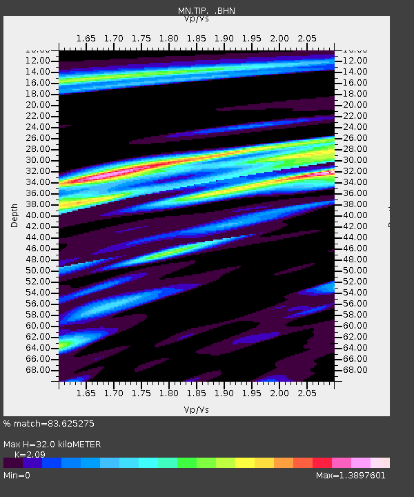
TIP Timpagrande, Italy - Earthquake Result Viewer
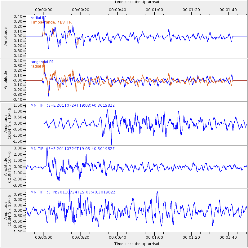
Earthquake location: Near East Coast Of Honshu, Japan
Earthquake latitude/longitude: 37.7/141.4
Earthquake time(UTC): 2011/07/24 (205) 18:51:24 GMT
Earthquake Depth: 35 km
Earthquake Magnitude: 6.3 MB, 5.9 MS, 6.3 MW, 6.3 MW
Earthquake Catalog/Contributor: WHDF/NEIC
Network: MN MEDNET Project
Station: TIP Timpagrande, Italy
Lat/Lon: 39.18 N/16.76 E
Elevation: 789 m
Distance: 88.1 deg
Az: 320.219 deg
Baz: 40.75 deg
Ray Param: 0.042789653
Estimated Moho Depth: 32.0 km
Estimated Crust Vp/Vs: 2.09
Assumed Crust Vp: 6.1 km/s
Estimated Crust Vs: 2.919 km/s
Estimated Crust Poisson's Ratio: 0.35
Radial Match: 83.625275 %
Radial Bump: 400
Transverse Match: 67.30118 %
Transverse Bump: 400
SOD ConfigId: 405110
Insert Time: 2011-12-29 05:47:54.543 +0000
GWidth: 2.5
Max Bumps: 400
Tol: 0.001

Signal To Noise

ChannelStoNSTALTA
MN:TIP: :BHZ:20110724T19:03:40.301982Z4.06902171.1026755E-62.7099276E-7
MN:TIP: :BHN:20110724T19:03:40.301982Z1.05508592.499813E-72.3692981E-7
MN:TIP: :BHE:20110724T19:03:40.301982Z2.68547425.9380415E-72.2111706E-7
Arrivals
Ps5.8 SECOND
PpPs16 SECOND
PsPs/PpSs22 SECOND