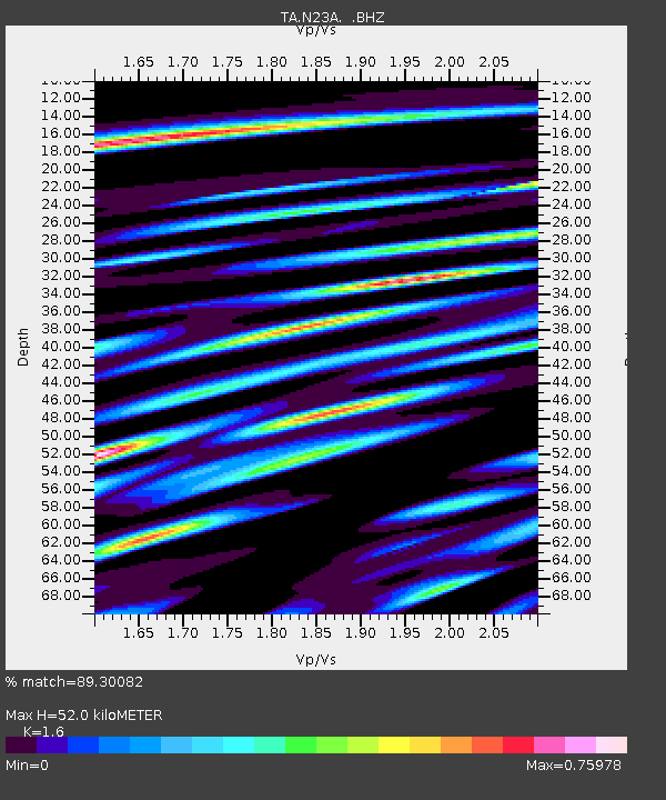
N23A Red Feather Lakes, CO, USA - Earthquake Result Viewer
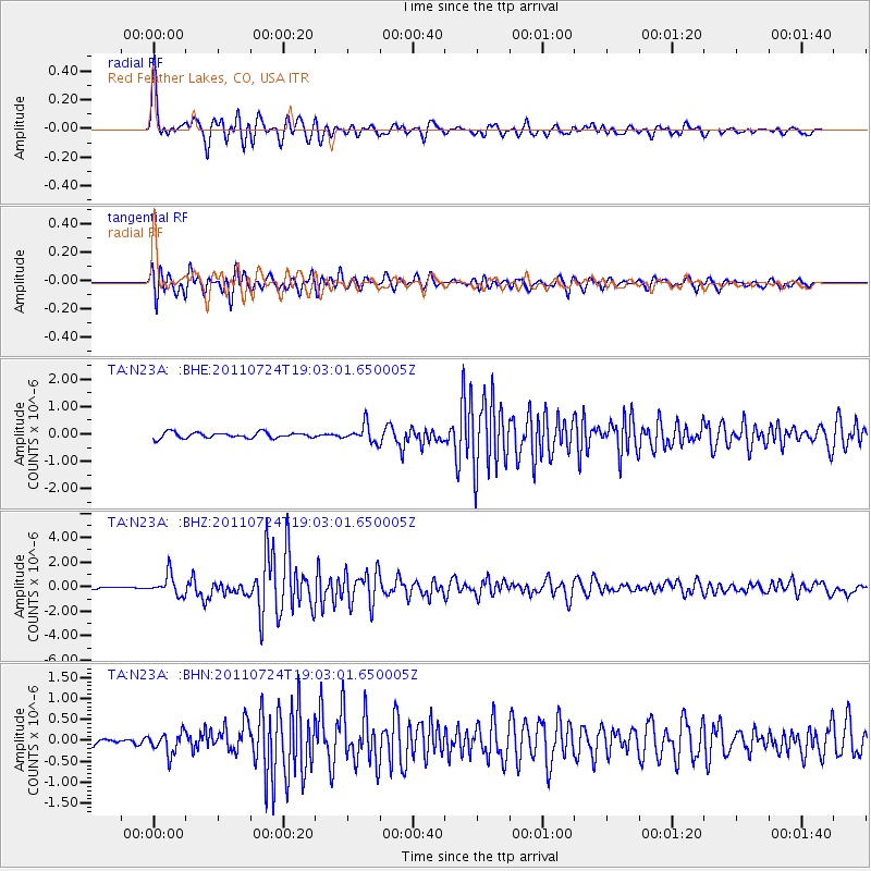
Earthquake location: Near East Coast Of Honshu, Japan
Earthquake latitude/longitude: 37.7/141.4
Earthquake time(UTC): 2011/07/24 (205) 18:51:24 GMT
Earthquake Depth: 35 km
Earthquake Magnitude: 6.3 MB, 5.9 MS, 6.3 MW, 6.3 MW
Earthquake Catalog/Contributor: WHDF/NEIC
Network: TA USArray Transportable Network (new EarthScope stations)
Station: N23A Red Feather Lakes, CO, USA
Lat/Lon: 40.89 N/105.94 W
Elevation: 2458 m
Distance: 80.5 deg
Az: 45.184 deg
Baz: 312.101 deg
Ray Param: 0.04821421
Estimated Moho Depth: 52.0 km
Estimated Crust Vp/Vs: 1.60
Assumed Crust Vp: 6.306 km/s
Estimated Crust Vs: 3.941 km/s
Estimated Crust Poisson's Ratio: 0.18
Radial Match: 89.30082 %
Radial Bump: 400
Transverse Match: 88.12802 %
Transverse Bump: 400
SOD ConfigId: 405110
Insert Time: 2011-12-29 05:52:08.093 +0000
GWidth: 2.5
Max Bumps: 400
Tol: 0.001

Signal To Noise

ChannelStoNSTALTA
TA:N23A: :BHZ:20110724T19:03:01.650005Z10.2662488.2947105E-78.079593E-8
TA:N23A: :BHN:20110724T19:03:01.650005Z2.6984972.5305826E-79.377748E-8
TA:N23A: :BHE:20110724T19:03:01.650005Z2.99669673.145357E-71.04960804E-7
Arrivals
Ps5.1 SECOND
PpPs21 SECOND
PsPs/PpSs26 SECOND