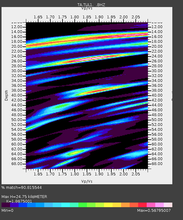
TUL1 Leonard, OK, USA - Earthquake Result Viewer
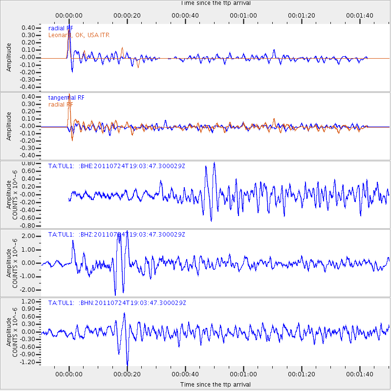
Earthquake location: Near East Coast Of Honshu, Japan
Earthquake latitude/longitude: 37.7/141.4
Earthquake time(UTC): 2011/07/24 (205) 18:51:24 GMT
Earthquake Depth: 35 km
Earthquake Magnitude: 6.3 MB, 5.9 MS, 6.3 MW, 6.3 MW
Earthquake Catalog/Contributor: WHDF/NEIC
Network: TA USArray Transportable Network (new EarthScope stations)
Station: TUL1 Leonard, OK, USA
Lat/Lon: 35.91 N/95.79 W
Elevation: 256 m
Distance: 89.6 deg
Az: 43.022 deg
Baz: 318.209 deg
Ray Param: 0.0417288
Estimated Moho Depth: 24.75 km
Estimated Crust Vp/Vs: 1.87
Assumed Crust Vp: 6.498 km/s
Estimated Crust Vs: 3.479 km/s
Estimated Crust Poisson's Ratio: 0.30
Radial Match: 90.815544 %
Radial Bump: 400
Transverse Match: 73.86673 %
Transverse Bump: 400
SOD ConfigId: 405110
Insert Time: 2011-12-29 05:52:31.239 +0000
GWidth: 2.5
Max Bumps: 400
Tol: 0.001

Signal To Noise

ChannelStoNSTALTA
TA:TUL1: :BHZ:20110724T19:03:47.300029Z7.17956165.892595E-78.2074585E-8
TA:TUL1: :BHN:20110724T19:03:47.300029Z1.77312091.5251547E-78.601526E-8
TA:TUL1: :BHE:20110724T19:03:47.300029Z2.03465751.3471936E-76.62123E-8
Arrivals
Ps3.4 SECOND
PpPs11 SECOND
PsPs/PpSs14 SECOND