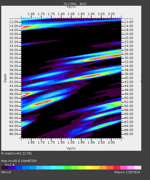
F29A Eureka, SD, USA - Earthquake Result Viewer
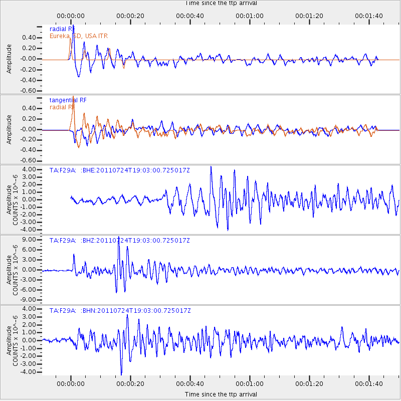
Earthquake location: Near East Coast Of Honshu, Japan
Earthquake latitude/longitude: 37.7/141.4
Earthquake time(UTC): 2011/07/24 (205) 18:51:24 GMT
Earthquake Depth: 35 km
Earthquake Magnitude: 6.3 MB, 5.9 MS, 6.3 MW, 6.3 MW
Earthquake Catalog/Contributor: WHDF/NEIC
Network: TA USArray Transportable Network (new EarthScope stations)
Station: F29A Eureka, SD, USA
Lat/Lon: 45.83 N/99.83 W
Elevation: 575 m
Distance: 80.3 deg
Az: 38.441 deg
Baz: 315.163 deg
Ray Param: 0.048332907
Estimated Moho Depth: 48.0 km
Estimated Crust Vp/Vs: 1.60
Assumed Crust Vp: 6.53 km/s
Estimated Crust Vs: 4.082 km/s
Estimated Crust Poisson's Ratio: 0.18
Radial Match: 92.21781 %
Radial Bump: 400
Transverse Match: 80.175 %
Transverse Bump: 400
SOD ConfigId: 405110
Insert Time: 2011-12-29 05:53:15.540 +0000
GWidth: 2.5
Max Bumps: 400
Tol: 0.001

Signal To Noise

ChannelStoNSTALTA
TA:F29A: :BHZ:20110724T19:03:00.725017Z11.7725951.4473321E-61.2294079E-7
TA:F29A: :BHN:20110724T19:03:00.725017Z1.87715086.576202E-73.5032892E-7
TA:F29A: :BHE:20110724T19:03:00.725017Z2.34652337.280881E-73.1028375E-7
Arrivals
Ps4.6 SECOND
PpPs19 SECOND
PsPs/PpSs23 SECOND