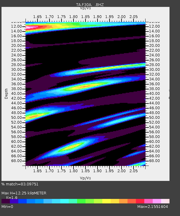
F30A Leola, SD, USA - Earthquake Result Viewer

Earthquake location: Near East Coast Of Honshu, Japan
Earthquake latitude/longitude: 37.7/141.4
Earthquake time(UTC): 2011/07/24 (205) 18:51:24 GMT
Earthquake Depth: 35 km
Earthquake Magnitude: 6.3 MB, 5.9 MS, 6.3 MW, 6.3 MW
Earthquake Catalog/Contributor: WHDF/NEIC
Network: TA USArray Transportable Network (new EarthScope stations)
Station: F30A Leola, SD, USA
Lat/Lon: 45.84 N/99.03 W
Elevation: 601 m
Distance: 80.7 deg
Az: 38.035 deg
Baz: 315.669 deg
Ray Param: 0.048066765
Estimated Moho Depth: 12.25 km
Estimated Crust Vp/Vs: 1.60
Assumed Crust Vp: 6.53 km/s
Estimated Crust Vs: 4.082 km/s
Estimated Crust Poisson's Ratio: 0.18
Radial Match: 83.09751 %
Radial Bump: 400
Transverse Match: 87.24841 %
Transverse Bump: 400
SOD ConfigId: 405110
Insert Time: 2011-12-29 05:53:20.826 +0000
GWidth: 2.5
Max Bumps: 400
Tol: 0.001

Signal To Noise

ChannelStoNSTALTA
TA:F30A: :BHZ:20110724T19:03:02.824993Z10.5699071.2362907E-61.1696325E-7
TA:F30A: :BHN:20110724T19:03:02.824993Z1.73987634.649329E-72.6722182E-7
TA:F30A: :BHE:20110724T19:03:02.824993Z2.89951428.04339E-72.7740472E-7
Arrivals
Ps1.2 SECOND
PpPs4.7 SECOND
PsPs/PpSs5.9 SECOND