You are here: Home > Network List > TA - USArray Transportable Network (new EarthScope stations) Stations List
> Station L31A Butterfield Farm, Chambers, NE, USA > Earthquake Result Viewer
L31A Butterfield Farm, Chambers, NE, USA - Earthquake Result Viewer
| Earthquake location: |
Near East Coast Of Honshu, Japan |
| Earthquake latitude/longitude: |
37.7/141.4 |
| Earthquake time(UTC): |
2011/07/24 (205) 18:51:24 GMT |
| Earthquake Depth: |
35 km |
| Earthquake Magnitude: |
6.3 MB, 5.9 MS, 6.3 MW, 6.3 MW |
| Earthquake Catalog/Contributor: |
WHDF/NEIC |
|
| Network: |
TA USArray Transportable Network (new EarthScope stations) |
| Station: |
L31A Butterfield Farm, Chambers, NE, USA |
| Lat/Lon: |
42.18 N/98.84 W |
| Elevation: |
670 m |
|
| Distance: |
83.4 deg |
| Az: |
40.508 deg |
| Baz: |
316.141 deg |
| Ray Param: |
0.046168614 |
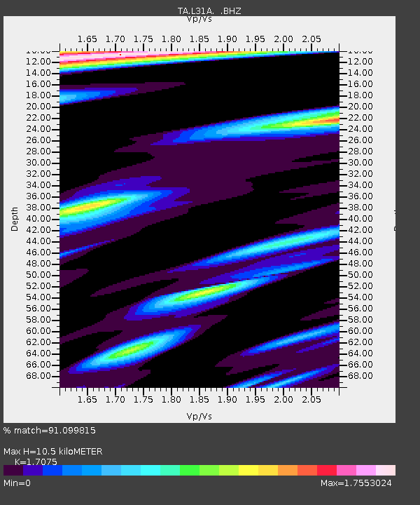
| Estimated Moho Depth: |
10.5 km |
| Estimated Crust Vp/Vs: |
1.71 |
| Assumed Crust Vp: |
6.53 km/s |
| Estimated Crust Vs: |
3.825 km/s |
| Estimated Crust Poisson's Ratio: |
0.24 |
|
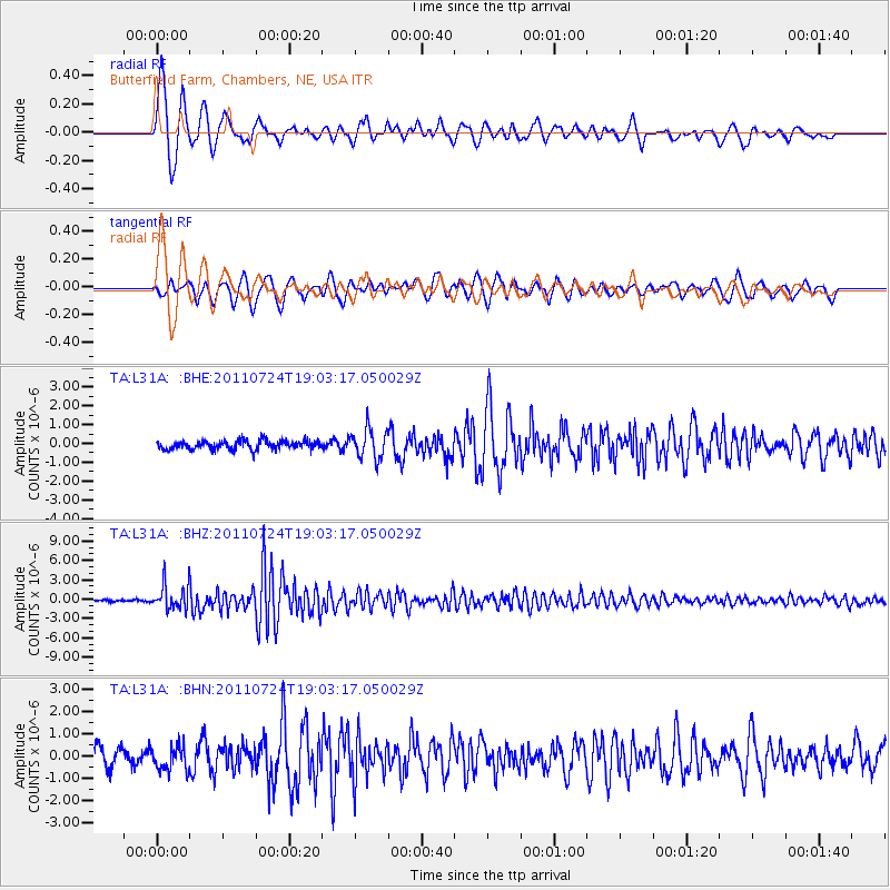
| Radial Match: |
91.099815 % |
| Radial Bump: |
400 |
| Transverse Match: |
80.67813 % |
| Transverse Bump: |
400 |
| SOD ConfigId: |
405110 |
| Insert Time: |
2011-12-29 05:53:34.184 +0000 |
| GWidth: |
2.5 |
| Max Bumps: |
400 |
| Tol: |
0.001 |
|
Signal To Noise
| Channel | StoN | STA | LTA |
| TA:L31A: :BHZ:20110724T19:03:17.050029Z | 12.920382 | 1.9102745E-6 | 1.4784969E-7 |
| TA:L31A: :BHN:20110724T19:03:17.050029Z | 1.5004909 | 5.367923E-7 | 3.5774445E-7 |
| TA:L31A: :BHE:20110724T19:03:17.050029Z | 3.3641002 | 7.777104E-7 | 2.3117933E-7 |
| Arrivals |
| Ps | 1.2 SECOND |
| PpPs | 4.2 SECOND |
| PsPs/PpSs | 5.4 SECOND |


