You are here: Home > Network List > TA - USArray Transportable Network (new EarthScope stations) Stations List
> Station O31A Woollen Ranch, Alma, NE, USA > Earthquake Result Viewer
O31A Woollen Ranch, Alma, NE, USA - Earthquake Result Viewer
| Earthquake location: |
Near East Coast Of Honshu, Japan |
| Earthquake latitude/longitude: |
37.7/141.4 |
| Earthquake time(UTC): |
2011/07/24 (205) 18:51:24 GMT |
| Earthquake Depth: |
35 km |
| Earthquake Magnitude: |
6.3 MB, 5.9 MS, 6.3 MW, 6.3 MW |
| Earthquake Catalog/Contributor: |
WHDF/NEIC |
|
| Network: |
TA USArray Transportable Network (new EarthScope stations) |
| Station: |
O31A Woollen Ranch, Alma, NE, USA |
| Lat/Lon: |
40.15 N/99.33 W |
| Elevation: |
631 m |
|
| Distance: |
84.6 deg |
| Az: |
42.185 deg |
| Baz: |
315.997 deg |
| Ray Param: |
0.045319717 |
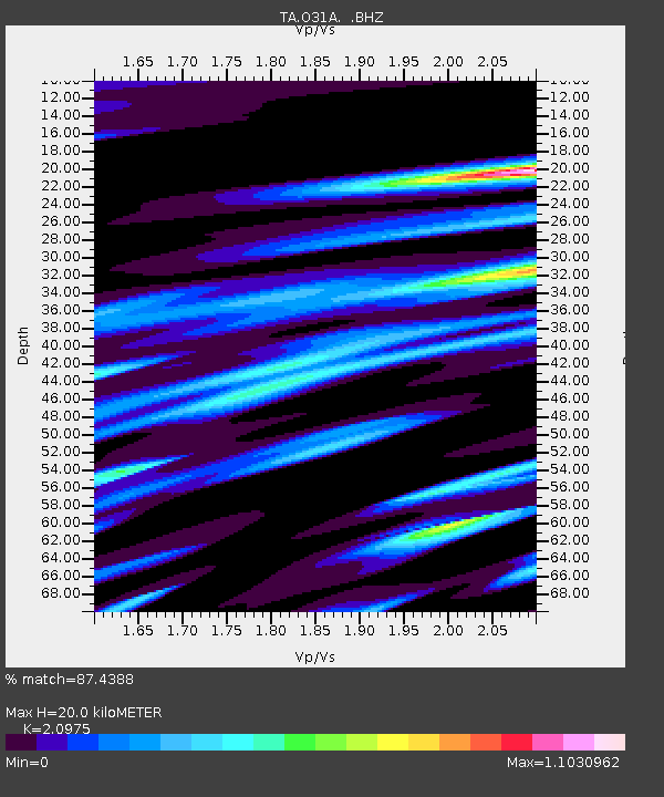
| Estimated Moho Depth: |
20.0 km |
| Estimated Crust Vp/Vs: |
2.10 |
| Assumed Crust Vp: |
6.53 km/s |
| Estimated Crust Vs: |
3.113 km/s |
| Estimated Crust Poisson's Ratio: |
0.35 |
|
| Radial Match: |
87.4388 % |
| Radial Bump: |
400 |
| Transverse Match: |
74.84271 % |
| Transverse Bump: |
400 |
| SOD ConfigId: |
405110 |
| Insert Time: |
2011-12-29 05:53:47.573 +0000 |
| GWidth: |
2.5 |
| Max Bumps: |
400 |
| Tol: |
0.001 |
|
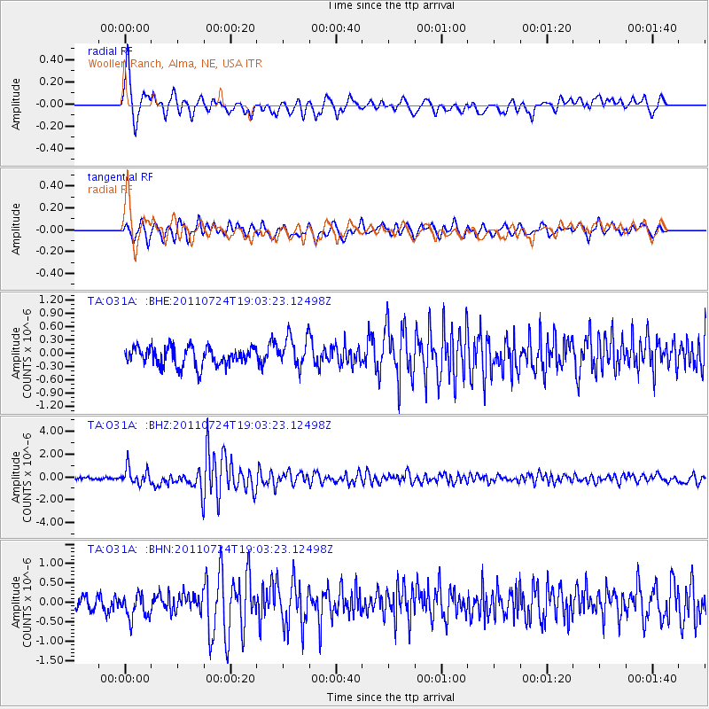
Signal To Noise
| Channel | StoN | STA | LTA |
| TA:O31A: :BHZ:20110724T19:03:23.12498Z | 6.865942 | 7.5265467E-7 | 1.09621475E-7 |
| TA:O31A: :BHN:20110724T19:03:23.12498Z | 1.9554265 | 3.3917672E-7 | 1.734541E-7 |
| TA:O31A: :BHE:20110724T19:03:23.12498Z | 1.7099103 | 3.5336393E-7 | 2.0665642E-7 |
| Arrivals |
| Ps | 3.4 SECOND |
| PpPs | 9.3 SECOND |
| PsPs/PpSs | 13 SECOND |


