You are here: Home > Network List > TA - USArray Transportable Network (new EarthScope stations) Stations List
> Station P32A Huiting Farm, Downs, KS, USA > Earthquake Result Viewer
P32A Huiting Farm, Downs, KS, USA - Earthquake Result Viewer
| Earthquake location: |
Near East Coast Of Honshu, Japan |
| Earthquake latitude/longitude: |
37.7/141.4 |
| Earthquake time(UTC): |
2011/07/24 (205) 18:51:24 GMT |
| Earthquake Depth: |
35 km |
| Earthquake Magnitude: |
6.3 MB, 5.9 MS, 6.3 MW, 6.3 MW |
| Earthquake Catalog/Contributor: |
WHDF/NEIC |
|
| Network: |
TA USArray Transportable Network (new EarthScope stations) |
| Station: |
P32A Huiting Farm, Downs, KS, USA |
| Lat/Lon: |
39.62 N/98.60 W |
| Elevation: |
524 m |
|
| Distance: |
85.4 deg |
| Az: |
42.148 deg |
| Baz: |
316.457 deg |
| Ray Param: |
0.044768237 |
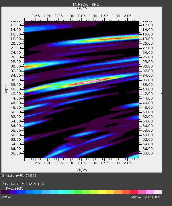
| Estimated Moho Depth: |
36.25 km |
| Estimated Crust Vp/Vs: |
1.89 |
| Assumed Crust Vp: |
6.483 km/s |
| Estimated Crust Vs: |
3.425 km/s |
| Estimated Crust Poisson's Ratio: |
0.31 |
|
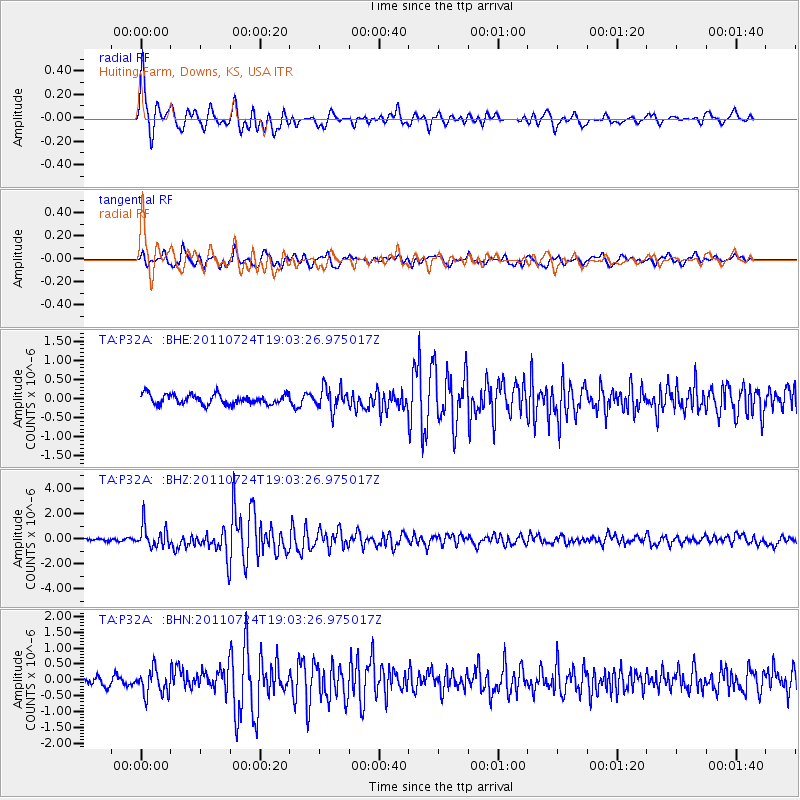
| Radial Match: |
91.71961 % |
| Radial Bump: |
400 |
| Transverse Match: |
88.177605 % |
| Transverse Bump: |
400 |
| SOD ConfigId: |
405110 |
| Insert Time: |
2011-12-29 05:54:00.566 +0000 |
| GWidth: |
2.5 |
| Max Bumps: |
400 |
| Tol: |
0.001 |
|
Signal To Noise
| Channel | StoN | STA | LTA |
| TA:P32A: :BHZ:20110724T19:03:26.975017Z | 10.383429 | 8.887195E-7 | 8.559018E-8 |
| TA:P32A: :BHN:20110724T19:03:26.975017Z | 3.6213067 | 3.9694953E-7 | 1.0961501E-7 |
| TA:P32A: :BHE:20110724T19:03:26.975017Z | 2.2526345 | 2.8903312E-7 | 1.2830893E-7 |
| Arrivals |
| Ps | 5.1 SECOND |
| PpPs | 16 SECOND |
| PsPs/PpSs | 21 SECOND |


