You are here: Home > Network List > TA - USArray Transportable Network (new EarthScope stations) Stations List
> Station V32A Arapaho, OK, USA > Earthquake Result Viewer
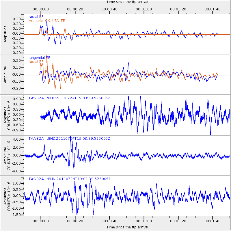
V32A Arapaho, OK, USA - Earthquake Result Viewer
*The percent match for this event was below the threshold and hence no stack was calculated.
| Earthquake location: |
Near East Coast Of Honshu, Japan |
| Earthquake latitude/longitude: |
37.7/141.4 |
| Earthquake time(UTC): |
2011/07/24 (205) 18:51:24 GMT |
| Earthquake Depth: |
35 km |
| Earthquake Magnitude: |
6.3 MB, 5.9 MS, 6.3 MW, 6.3 MW |
| Earthquake Catalog/Contributor: |
WHDF/NEIC |
|
| Network: |
TA USArray Transportable Network (new EarthScope stations) |
| Station: |
V32A Arapaho, OK, USA |
| Lat/Lon: |
35.72 N/99.04 W |
| Elevation: |
533 m |
|
| Distance: |
87.9 deg |
| Az: |
45.093 deg |
| Baz: |
316.359 deg |
| Ray Param: |
$rayparam |
*The percent match for this event was below the threshold and hence was not used in the summary stack. |
|
| Radial Match: |
87.338684 % |
| Radial Bump: |
400 |
| Transverse Match: |
75.75473 % |
| Transverse Bump: |
400 |
| SOD ConfigId: |
405110 |
| Insert Time: |
2011-12-29 05:55:59.677 +0000 |
| GWidth: |
2.5 |
| Max Bumps: |
400 |
| Tol: |
0.001 |
|
Signal To Noise
| Channel | StoN | STA | LTA |
| TA:V32A: :BHZ:20110724T19:03:39.525005Z | 5.3519125 | 9.265385E-7 | 1.7312288E-7 |
| TA:V32A: :BHN:20110724T19:03:39.525005Z | 1.8842051 | 2.8948196E-7 | 1.5363612E-7 |
| TA:V32A: :BHE:20110724T19:03:39.525005Z | 1.0806823 | 2.0164788E-7 | 1.8659313E-7 |
| Arrivals |
| Ps | |
| PpPs | |
| PsPs/PpSs | |


