You are here: Home > Network List > TA - USArray Transportable Network (new EarthScope stations) Stations List
> Station X34A Smith Ranch, Marlow, OK, USA > Earthquake Result Viewer
X34A Smith Ranch, Marlow, OK, USA - Earthquake Result Viewer
| Earthquake location: |
Near East Coast Of Honshu, Japan |
| Earthquake latitude/longitude: |
37.7/141.4 |
| Earthquake time(UTC): |
2011/07/24 (205) 18:51:24 GMT |
| Earthquake Depth: |
35 km |
| Earthquake Magnitude: |
6.3 MB, 5.9 MS, 6.3 MW, 6.3 MW |
| Earthquake Catalog/Contributor: |
WHDF/NEIC |
|
| Network: |
TA USArray Transportable Network (new EarthScope stations) |
| Station: |
X34A Smith Ranch, Marlow, OK, USA |
| Lat/Lon: |
34.60 N/97.83 W |
| Elevation: |
364 m |
|
| Distance: |
89.4 deg |
| Az: |
45.136 deg |
| Baz: |
317.054 deg |
| Ray Param: |
0.04180442 |
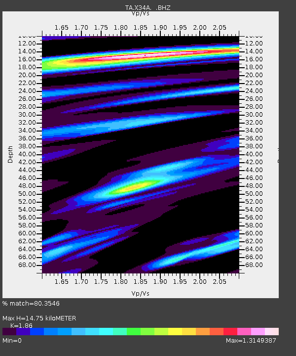
| Estimated Moho Depth: |
14.75 km |
| Estimated Crust Vp/Vs: |
1.86 |
| Assumed Crust Vp: |
6.426 km/s |
| Estimated Crust Vs: |
3.455 km/s |
| Estimated Crust Poisson's Ratio: |
0.30 |
|
| Radial Match: |
80.3546 % |
| Radial Bump: |
400 |
| Transverse Match: |
77.87977 % |
| Transverse Bump: |
400 |
| SOD ConfigId: |
405110 |
| Insert Time: |
2011-12-29 05:56:28.255 +0000 |
| GWidth: |
2.5 |
| Max Bumps: |
400 |
| Tol: |
0.001 |
|
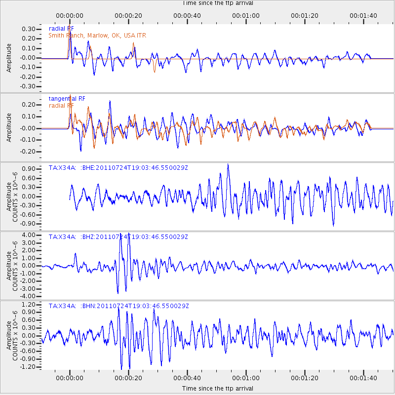
Signal To Noise
| Channel | StoN | STA | LTA |
| TA:X34A: :BHZ:20110724T19:03:46.550029Z | 4.4298677 | 5.7695826E-7 | 1.3024278E-7 |
| TA:X34A: :BHN:20110724T19:03:46.550029Z | 1.1101652 | 1.8043463E-7 | 1.6252952E-7 |
| TA:X34A: :BHE:20110724T19:03:46.550029Z | 1.1981249 | 2.0798178E-7 | 1.735894E-7 |
| Arrivals |
| Ps | 2.0 SECOND |
| PpPs | 6.4 SECOND |
| PsPs/PpSs | 8.4 SECOND |


