You are here: Home > Network List > TA - USArray Transportable Network (new EarthScope stations) Stations List
> Station 135A Vickery Place, Crowley, TX, USA > Earthquake Result Viewer
135A Vickery Place, Crowley, TX, USA - Earthquake Result Viewer
| Earthquake location: |
Near East Coast Of Honshu, Japan |
| Earthquake latitude/longitude: |
37.7/141.4 |
| Earthquake time(UTC): |
2011/07/24 (205) 18:51:24 GMT |
| Earthquake Depth: |
35 km |
| Earthquake Magnitude: |
6.3 MB, 5.9 MS, 6.3 MW, 6.3 MW |
| Earthquake Catalog/Contributor: |
WHDF/NEIC |
|
| Network: |
TA USArray Transportable Network (new EarthScope stations) |
| Station: |
135A Vickery Place, Crowley, TX, USA |
| Lat/Lon: |
32.56 N/97.41 W |
| Elevation: |
270 m |
|
| Distance: |
91.2 deg |
| Az: |
46.263 deg |
| Baz: |
317.281 deg |
| Ray Param: |
0.04161652 |
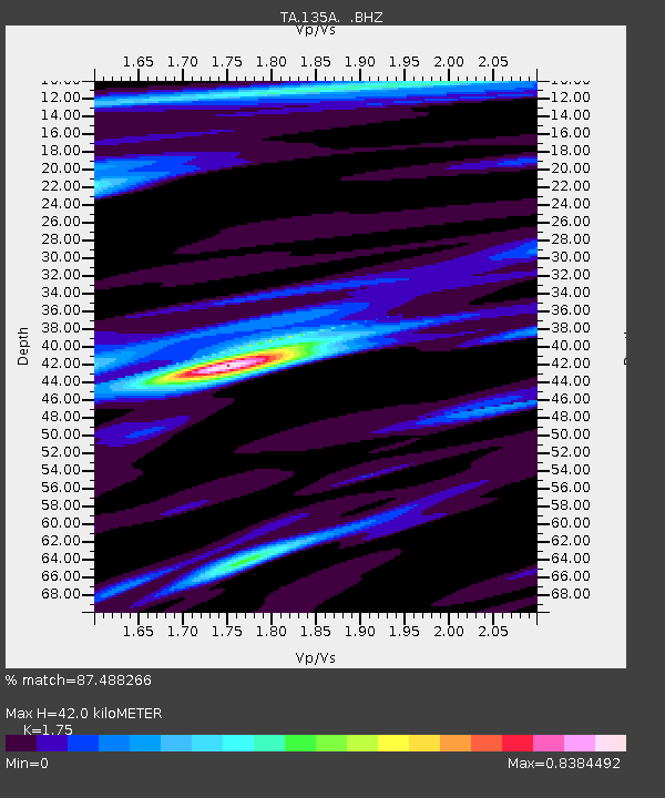
| Estimated Moho Depth: |
42.0 km |
| Estimated Crust Vp/Vs: |
1.75 |
| Assumed Crust Vp: |
6.38 km/s |
| Estimated Crust Vs: |
3.646 km/s |
| Estimated Crust Poisson's Ratio: |
0.26 |
|
| Radial Match: |
87.488266 % |
| Radial Bump: |
400 |
| Transverse Match: |
78.53161 % |
| Transverse Bump: |
400 |
| SOD ConfigId: |
405110 |
| Insert Time: |
2011-12-29 05:57:29.250 +0000 |
| GWidth: |
2.5 |
| Max Bumps: |
400 |
| Tol: |
0.001 |
|

Signal To Noise
| Channel | StoN | STA | LTA |
| TA:135A: :BHZ:20110724T19:03:54.574993Z | 6.4504056 | 6.119153E-7 | 9.4864625E-8 |
| TA:135A: :BHN:20110724T19:03:54.574993Z | 1.3870898 | 1.3045876E-7 | 9.405213E-8 |
| TA:135A: :BHE:20110724T19:03:54.574993Z | 0.90039474 | 7.747746E-8 | 8.6048324E-8 |
| Arrivals |
| Ps | 5.0 SECOND |
| PpPs | 18 SECOND |
| PsPs/PpSs | 23 SECOND |


