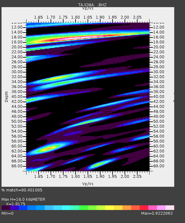
X36A Centrahoma, OK, USA - Earthquake Result Viewer
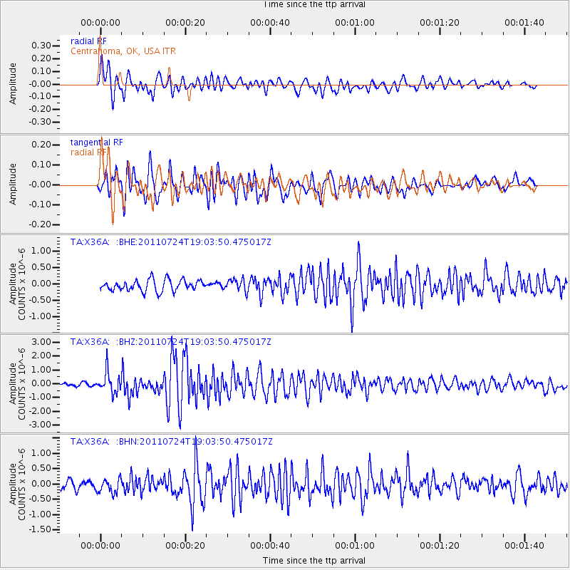
Earthquake location: Near East Coast Of Honshu, Japan
Earthquake latitude/longitude: 37.7/141.4
Earthquake time(UTC): 2011/07/24 (205) 18:51:24 GMT
Earthquake Depth: 35 km
Earthquake Magnitude: 6.3 MB, 5.9 MS, 6.3 MW, 6.3 MW
Earthquake Catalog/Contributor: WHDF/NEIC
Network: TA USArray Transportable Network (new EarthScope stations)
Station: X36A Centrahoma, OK, USA
Lat/Lon: 34.57 N/96.35 W
Elevation: 211 m
Distance: 90.3 deg
Az: 44.257 deg
Baz: 317.889 deg
Ray Param: 0.041679744
Estimated Moho Depth: 16.0 km
Estimated Crust Vp/Vs: 1.82
Assumed Crust Vp: 6.426 km/s
Estimated Crust Vs: 3.536 km/s
Estimated Crust Poisson's Ratio: 0.28
Radial Match: 80.401085 %
Radial Bump: 400
Transverse Match: 81.87936 %
Transverse Bump: 400
SOD ConfigId: 405110
Insert Time: 2011-12-29 06:02:34.499 +0000
GWidth: 2.5
Max Bumps: 400
Tol: 0.001

Signal To Noise

ChannelStoNSTALTA
TA:X36A: :BHZ:20110724T19:03:50.475017Z8.1842117.7432753E-79.461236E-8
TA:X36A: :BHN:20110724T19:03:50.475017Z1.78729462.2945328E-71.2838022E-7
TA:X36A: :BHE:20110724T19:03:50.475017Z1.06291541.7985866E-71.6921257E-7
Arrivals
Ps2.1 SECOND
PpPs6.9 SECOND
PsPs/PpSs9.0 SECOND