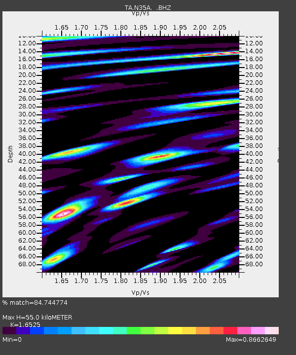
N35A Tabor, IA, USA - Earthquake Result Viewer
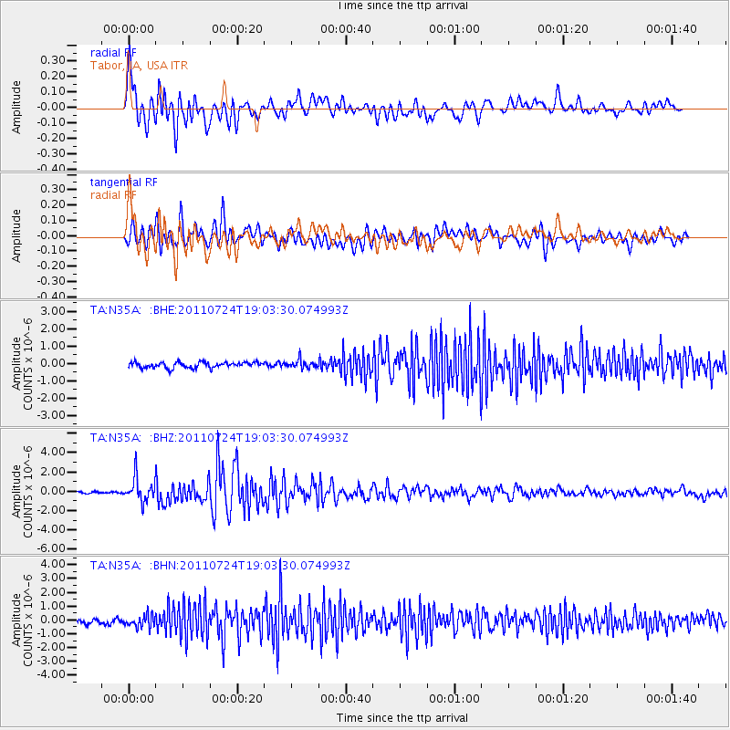
Earthquake location: Near East Coast Of Honshu, Japan
Earthquake latitude/longitude: 37.7/141.4
Earthquake time(UTC): 2011/07/24 (205) 18:51:24 GMT
Earthquake Depth: 35 km
Earthquake Magnitude: 6.3 MB, 5.9 MS, 6.3 MW, 6.3 MW
Earthquake Catalog/Contributor: WHDF/NEIC
Network: TA USArray Transportable Network (new EarthScope stations)
Station: N35A Tabor, IA, USA
Lat/Lon: 40.86 N/95.64 W
Elevation: 353 m
Distance: 86.0 deg
Az: 39.637 deg
Baz: 318.172 deg
Ray Param: 0.044321746
Estimated Moho Depth: 55.0 km
Estimated Crust Vp/Vs: 1.65
Assumed Crust Vp: 6.498 km/s
Estimated Crust Vs: 3.932 km/s
Estimated Crust Poisson's Ratio: 0.21
Radial Match: 84.744774 %
Radial Bump: 400
Transverse Match: 85.01349 %
Transverse Bump: 400
SOD ConfigId: 405110
Insert Time: 2011-12-29 06:04:06.225 +0000
GWidth: 2.5
Max Bumps: 400
Tol: 0.001

Signal To Noise

ChannelStoNSTALTA
TA:N35A: :BHZ:20110724T19:03:30.074993Z13.9660891.2266634E-68.783155E-8
TA:N35A: :BHN:20110724T19:03:30.074993Z2.9926254.313412E-71.4413473E-7
TA:N35A: :BHE:20110724T19:03:30.074993Z1.4651752.3829391E-71.6263853E-7
Arrivals
Ps5.7 SECOND
PpPs22 SECOND
PsPs/PpSs28 SECOND