You are here: Home > Network List > TA - USArray Transportable Network (new EarthScope stations) Stations List
> Station T37A Cheneyville 1850, Columbus, KS, USA > Earthquake Result Viewer
T37A Cheneyville 1850, Columbus, KS, USA - Earthquake Result Viewer
| Earthquake location: |
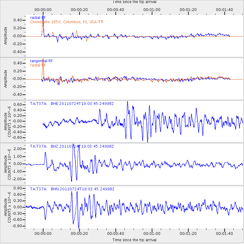
Near East Coast Of Honshu, Japan |
| Earthquake latitude/longitude: |
37.7/141.4 |
| Earthquake time(UTC): |
2011/07/24 (205) 18:51:24 GMT |
| Earthquake Depth: |
35 km |
| Earthquake Magnitude: |
6.3 MB, 5.9 MS, 6.3 MW, 6.3 MW |
| Earthquake Catalog/Contributor: |
WHDF/NEIC |
|
| Network: |
TA USArray Transportable Network (new EarthScope stations) |
| Station: |
T37A Cheneyville 1850, Columbus, KS, USA |
| Lat/Lon: |
37.12 N/94.92 W |
| Elevation: |
256 m |
|
| Distance: |
89.2 deg |
| Az: |
41.692 deg |
| Baz: |
318.713 deg |
| Ray Param: |
0.042007152 |
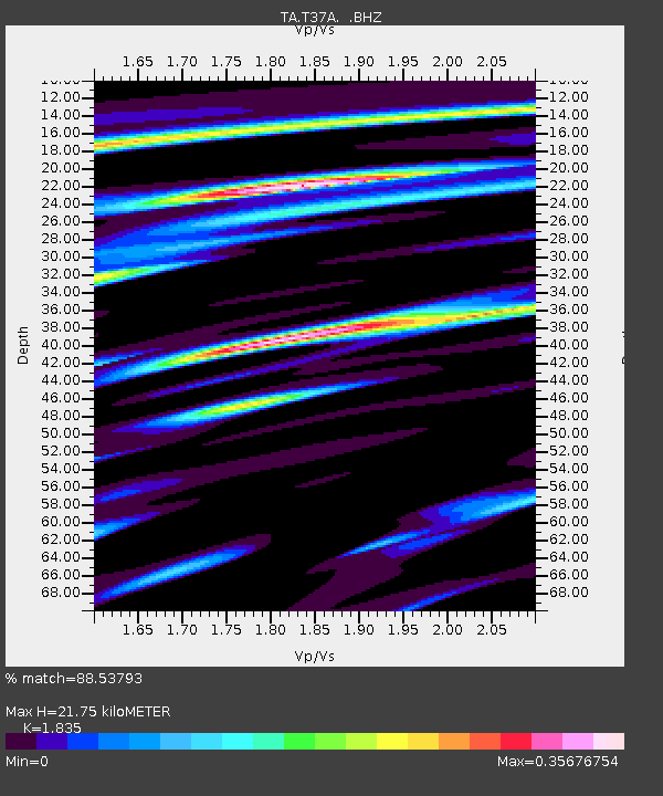
| Estimated Moho Depth: |
21.75 km |
| Estimated Crust Vp/Vs: |
1.84 |
| Assumed Crust Vp: |
6.53 km/s |
| Estimated Crust Vs: |
3.559 km/s |
| Estimated Crust Poisson's Ratio: |
0.29 |
|
| Radial Match: |
88.53793 % |
| Radial Bump: |
400 |
| Transverse Match: |
78.79838 % |
| Transverse Bump: |
400 |
| SOD ConfigId: |
405110 |
| Insert Time: |
2011-12-29 06:04:45.129 +0000 |
| GWidth: |
2.5 |
| Max Bumps: |
400 |
| Tol: |
0.001 |
|
Signal To Noise
| Channel | StoN | STA | LTA |
| TA:T37A: :BHZ:20110724T19:03:45.24998Z | 6.7710795 | 5.992345E-7 | 8.8499114E-8 |
| TA:T37A: :BHN:20110724T19:03:45.24998Z | 3.7078059 | 2.146358E-7 | 5.788755E-8 |
| TA:T37A: :BHE:20110724T19:03:45.24998Z | 2.2757335 | 1.6502322E-7 | 7.25143E-8 |
| Arrivals |
| Ps | 2.8 SECOND |
| PpPs | 9.2 SECOND |
| PsPs/PpSs | 12 SECOND |


