You are here: Home > Network List > TA - USArray Transportable Network (new EarthScope stations) Stations List
> Station L35A Bielow Farm, Ricketts, IA, USA > Earthquake Result Viewer
L35A Bielow Farm, Ricketts, IA, USA - Earthquake Result Viewer
| Earthquake location: |
Near East Coast Of Honshu, Japan |
| Earthquake latitude/longitude: |
37.7/141.4 |
| Earthquake time(UTC): |
2011/07/24 (205) 18:51:24 GMT |
| Earthquake Depth: |
35 km |
| Earthquake Magnitude: |
6.3 MB, 5.9 MS, 6.3 MW, 6.3 MW |
| Earthquake Catalog/Contributor: |
WHDF/NEIC |
|
| Network: |
TA USArray Transportable Network (new EarthScope stations) |
| Station: |
L35A Bielow Farm, Ricketts, IA, USA |
| Lat/Lon: |
42.11 N/95.54 W |
| Elevation: |
410 m |
|
| Distance: |
85.1 deg |
| Az: |
38.746 deg |
| Baz: |
318.167 deg |
| Ray Param: |
0.04495234 |
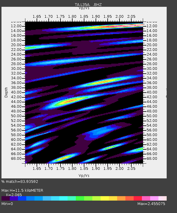
| Estimated Moho Depth: |
11.5 km |
| Estimated Crust Vp/Vs: |
2.07 |
| Assumed Crust Vp: |
6.53 km/s |
| Estimated Crust Vs: |
3.162 km/s |
| Estimated Crust Poisson's Ratio: |
0.35 |
|
| Radial Match: |
83.93592 % |
| Radial Bump: |
400 |
| Transverse Match: |
72.69182 % |
| Transverse Bump: |
400 |
| SOD ConfigId: |
405110 |
| Insert Time: |
2011-12-29 06:05:38.294 +0000 |
| GWidth: |
2.5 |
| Max Bumps: |
400 |
| Tol: |
0.001 |
|

Signal To Noise
| Channel | StoN | STA | LTA |
| TA:L35A: :BHZ:20110724T19:03:25.699993Z | 8.471501 | 6.338182E-7 | 7.481769E-8 |
| TA:L35A: :BHN:20110724T19:03:25.699993Z | 3.3430502 | 3.775773E-7 | 1.1294395E-7 |
| TA:L35A: :BHE:20110724T19:03:25.699993Z | 2.506946 | 2.850985E-7 | 1.1372343E-7 |
| Arrivals |
| Ps | 1.9 SECOND |
| PpPs | 5.3 SECOND |
| PsPs/PpSs | 7.2 SECOND |


