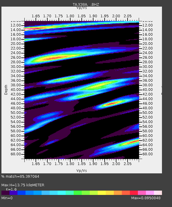
X38A Whitesboro, OK, USA - Earthquake Result Viewer
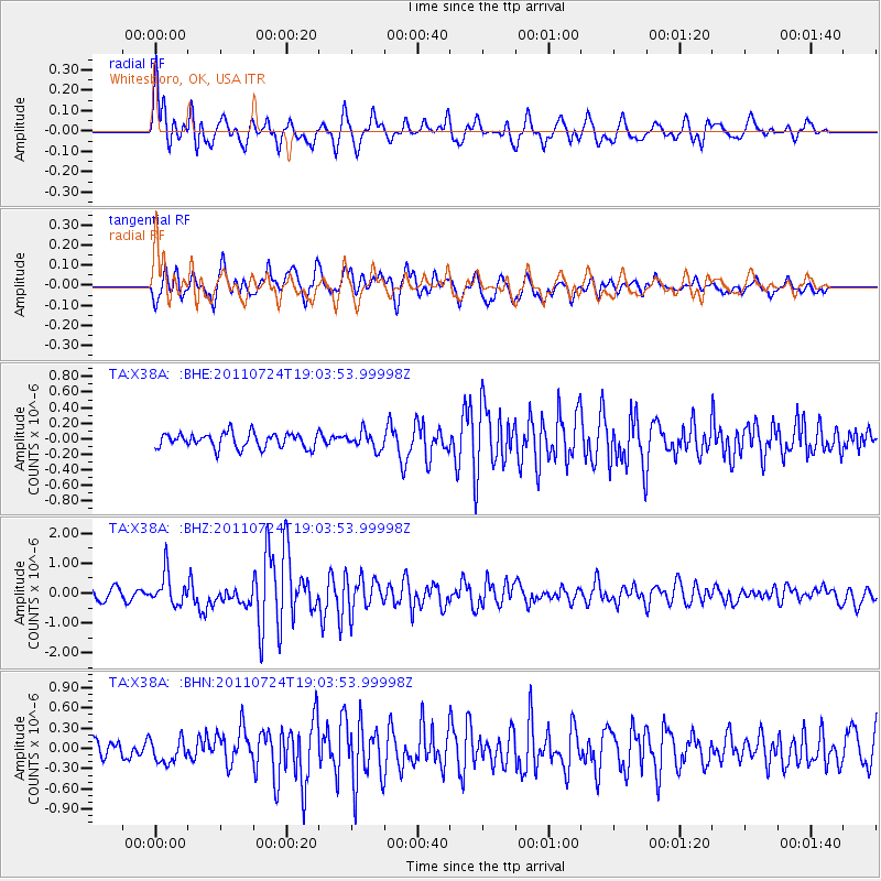
Earthquake location: Near East Coast Of Honshu, Japan
Earthquake latitude/longitude: 37.7/141.4
Earthquake time(UTC): 2011/07/24 (205) 18:51:24 GMT
Earthquake Depth: 35 km
Earthquake Magnitude: 6.3 MB, 5.9 MS, 6.3 MW, 6.3 MW
Earthquake Catalog/Contributor: WHDF/NEIC
Network: TA USArray Transportable Network (new EarthScope stations)
Station: X38A Whitesboro, OK, USA
Lat/Lon: 34.67 N/94.83 W
Elevation: 234 m
Distance: 91.0 deg
Az: 43.253 deg
Baz: 318.762 deg
Ray Param: 0.04162543
Estimated Moho Depth: 13.75 km
Estimated Crust Vp/Vs: 1.60
Assumed Crust Vp: 6.498 km/s
Estimated Crust Vs: 4.061 km/s
Estimated Crust Poisson's Ratio: 0.18
Radial Match: 85.397064 %
Radial Bump: 400
Transverse Match: 73.68068 %
Transverse Bump: 400
SOD ConfigId: 405110
Insert Time: 2011-12-29 06:05:40.524 +0000
GWidth: 2.5
Max Bumps: 400
Tol: 0.001

Signal To Noise

ChannelStoNSTALTA
TA:X38A: :BHZ:20110724T19:03:53.99998Z3.31289395.2821747E-71.5944292E-7
TA:X38A: :BHN:20110724T19:03:53.99998Z1.33650231.7657582E-71.3211786E-7
TA:X38A: :BHE:20110724T19:03:53.99998Z1.13844081.0916479E-79.5889725E-8
Arrivals
Ps1.3 SECOND
PpPs5.4 SECOND
PsPs/PpSs6.7 SECOND