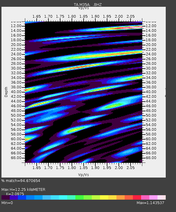
M35A Neola, IA, USA - Earthquake Result Viewer

Earthquake location: Near East Coast Of Honshu, Japan
Earthquake latitude/longitude: 37.7/141.4
Earthquake time(UTC): 2011/07/24 (205) 18:51:24 GMT
Earthquake Depth: 35 km
Earthquake Magnitude: 6.3 MB, 5.9 MS, 6.3 MW, 6.3 MW
Earthquake Catalog/Contributor: WHDF/NEIC
Network: TA USArray Transportable Network (new EarthScope stations)
Station: M35A Neola, IA, USA
Lat/Lon: 41.47 N/95.69 W
Elevation: 363 m
Distance: 85.5 deg
Az: 39.262 deg
Baz: 318.11 deg
Ray Param: 0.044661213
Estimated Moho Depth: 12.25 km
Estimated Crust Vp/Vs: 2.10
Assumed Crust Vp: 6.498 km/s
Estimated Crust Vs: 3.098 km/s
Estimated Crust Poisson's Ratio: 0.35
Radial Match: 94.670654 %
Radial Bump: 400
Transverse Match: 80.54732 %
Transverse Bump: 400
SOD ConfigId: 405110
Insert Time: 2011-12-29 06:06:07.085 +0000
GWidth: 2.5
Max Bumps: 400
Tol: 0.001

Signal To Noise

ChannelStoNSTALTA
TA:M35A: :BHZ:20110724T19:03:27.725017Z12.4341431.2715935E-61.0226628E-7
TA:M35A: :BHN:20110724T19:03:27.725017Z4.04400256.387451E-71.5794875E-7
TA:M35A: :BHE:20110724T19:03:27.725017Z3.7827155.7921966E-71.5312273E-7
Arrivals
Ps2.1 SECOND
PpPs5.7 SECOND
PsPs/PpSs7.8 SECOND