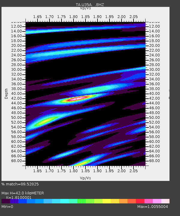
U35A Pawnee, OK, USA - Earthquake Result Viewer

Earthquake location: Near East Coast Of Honshu, Japan
Earthquake latitude/longitude: 37.7/141.4
Earthquake time(UTC): 2011/07/24 (205) 18:51:24 GMT
Earthquake Depth: 35 km
Earthquake Magnitude: 6.3 MB, 5.9 MS, 6.3 MW, 6.3 MW
Earthquake Catalog/Contributor: WHDF/NEIC
Network: TA USArray Transportable Network (new EarthScope stations)
Station: U35A Pawnee, OK, USA
Lat/Lon: 36.37 N/96.73 W
Elevation: 303 m
Distance: 88.7 deg
Az: 43.279 deg
Baz: 317.661 deg
Ray Param: 0.04230832
Estimated Moho Depth: 42.0 km
Estimated Crust Vp/Vs: 1.81
Assumed Crust Vp: 6.483 km/s
Estimated Crust Vs: 3.582 km/s
Estimated Crust Poisson's Ratio: 0.28
Radial Match: 89.52825 %
Radial Bump: 400
Transverse Match: 78.29002 %
Transverse Bump: 400
SOD ConfigId: 405110
Insert Time: 2011-12-29 06:06:45.981 +0000
GWidth: 2.5
Max Bumps: 400
Tol: 0.001

Signal To Noise

ChannelStoNSTALTA
TA:U35A: :BHZ:20110724T19:03:43.324993Z5.5910266.127738E-71.0959953E-7
TA:U35A: :BHN:20110724T19:03:43.324993Z1.35832441.7393315E-71.2804978E-7
TA:U35A: :BHE:20110724T19:03:43.324993Z1.0138798.1919794E-88.0798394E-8
Arrivals
Ps5.4 SECOND
PpPs18 SECOND
PsPs/PpSs23 SECOND