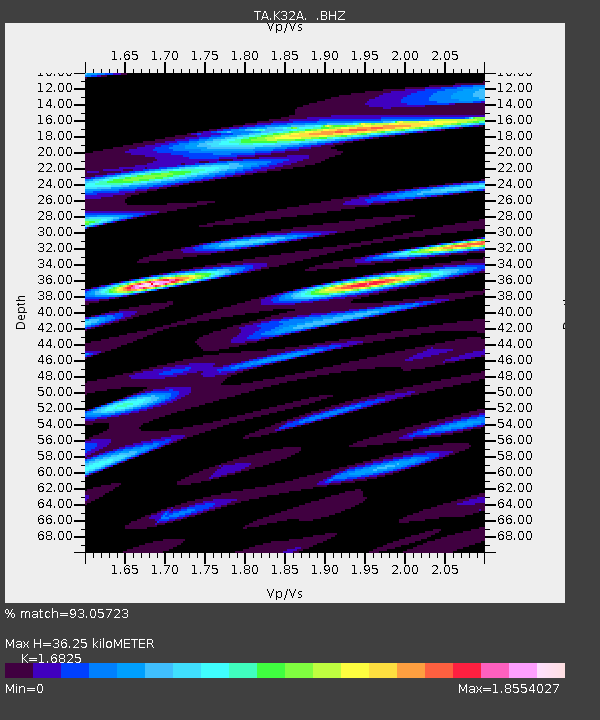
K32A Verdigre, NE, USA - Earthquake Result Viewer
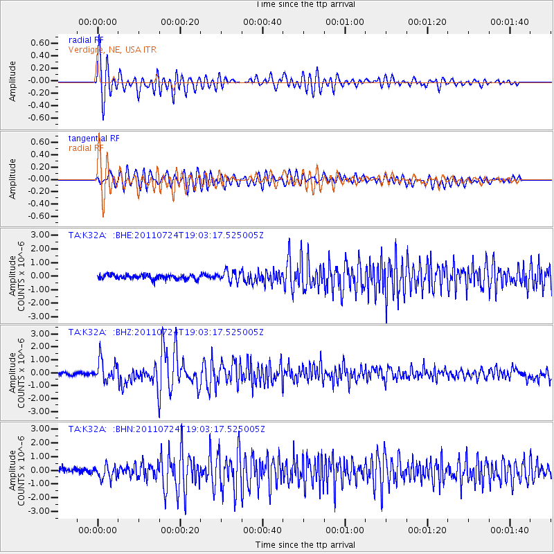
Earthquake location: Near East Coast Of Honshu, Japan
Earthquake latitude/longitude: 37.7/141.4
Earthquake time(UTC): 2011/07/24 (205) 18:51:24 GMT
Earthquake Depth: 35 km
Earthquake Magnitude: 6.3 MB, 5.9 MS, 6.3 MW, 6.3 MW
Earthquake Catalog/Contributor: WHDF/NEIC
Network: TA USArray Transportable Network (new EarthScope stations)
Station: K32A Verdigre, NE, USA
Lat/Lon: 42.66 N/97.97 W
Elevation: 512 m
Distance: 83.5 deg
Az: 39.704 deg
Baz: 316.631 deg
Ray Param: 0.04610269
Estimated Moho Depth: 36.25 km
Estimated Crust Vp/Vs: 1.68
Assumed Crust Vp: 6.498 km/s
Estimated Crust Vs: 3.862 km/s
Estimated Crust Poisson's Ratio: 0.23
Radial Match: 93.05723 %
Radial Bump: 400
Transverse Match: 87.05471 %
Transverse Bump: 400
SOD ConfigId: 405110
Insert Time: 2011-12-29 06:07:00.748 +0000
GWidth: 2.5
Max Bumps: 400
Tol: 0.001

Signal To Noise

ChannelStoNSTALTA
TA:K32A: :BHZ:20110724T19:03:17.525005Z8.8218948.3646364E-79.481679E-8
TA:K32A: :BHN:20110724T19:03:17.525005Z2.8850214.9720063E-71.7233867E-7
TA:K32A: :BHE:20110724T19:03:17.525005Z2.4299784.076545E-71.6776058E-7
Arrivals
Ps3.9 SECOND
PpPs15 SECOND
PsPs/PpSs18 SECOND