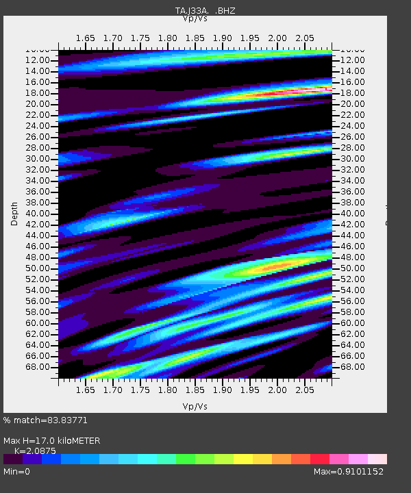
J33A Davis, SD, USA - Earthquake Result Viewer
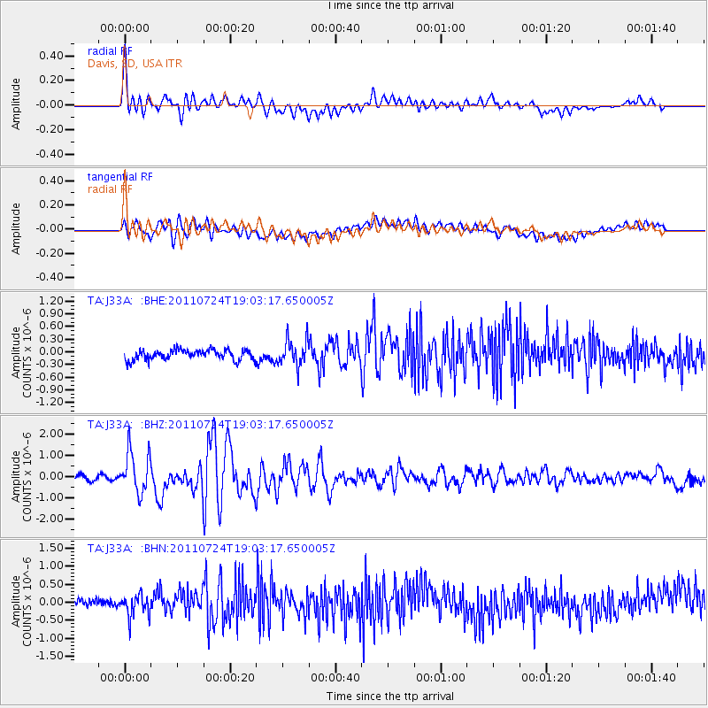
Earthquake location: Near East Coast Of Honshu, Japan
Earthquake latitude/longitude: 37.7/141.4
Earthquake time(UTC): 2011/07/24 (205) 18:51:24 GMT
Earthquake Depth: 35 km
Earthquake Magnitude: 6.3 MB, 5.9 MS, 6.3 MW, 6.3 MW
Earthquake Catalog/Contributor: WHDF/NEIC
Network: TA USArray Transportable Network (new EarthScope stations)
Station: J33A Davis, SD, USA
Lat/Lon: 43.32 N/96.97 W
Elevation: 400 m
Distance: 83.5 deg
Az: 38.709 deg
Baz: 317.202 deg
Ray Param: 0.04608624
Estimated Moho Depth: 17.0 km
Estimated Crust Vp/Vs: 2.09
Assumed Crust Vp: 6.498 km/s
Estimated Crust Vs: 3.113 km/s
Estimated Crust Poisson's Ratio: 0.35
Radial Match: 83.83771 %
Radial Bump: 400
Transverse Match: 62.099087 %
Transverse Bump: 400
SOD ConfigId: 405110
Insert Time: 2011-12-29 06:07:35.595 +0000
GWidth: 2.5
Max Bumps: 400
Tol: 0.001

Signal To Noise

ChannelStoNSTALTA
TA:J33A: :BHZ:20110724T19:03:17.650005Z11.4331559.816995E-78.586427E-8
TA:J33A: :BHN:20110724T19:03:17.650005Z1.63056392.9693248E-71.8210417E-7
TA:J33A: :BHE:20110724T19:03:17.650005Z2.56694053.1158118E-71.2138231E-7
Arrivals
Ps2.9 SECOND
PpPs7.9 SECOND
PsPs/PpSs11 SECOND