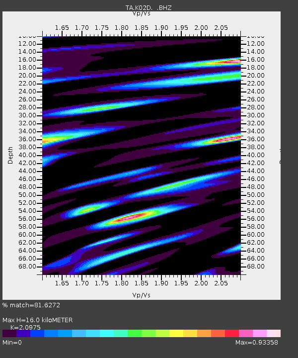
K02D Willamette Meridian, OR, USA - Earthquake Result Viewer
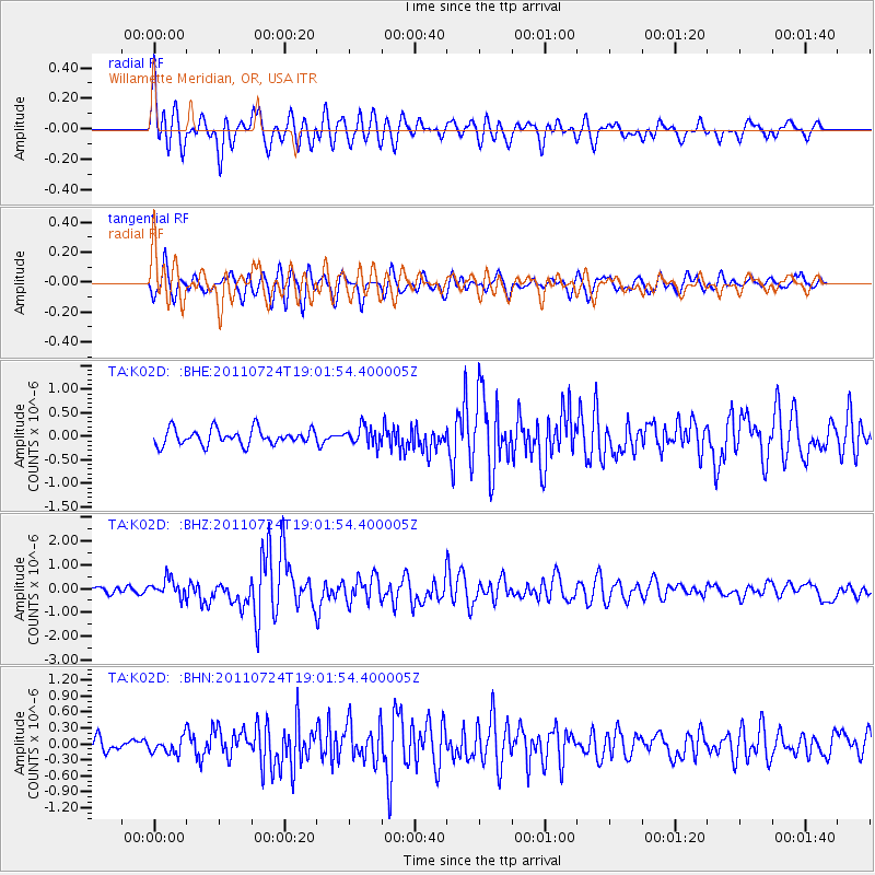
Earthquake location: Near East Coast Of Honshu, Japan
Earthquake latitude/longitude: 37.7/141.4
Earthquake time(UTC): 2011/07/24 (205) 18:51:24 GMT
Earthquake Depth: 35 km
Earthquake Magnitude: 6.3 MB, 5.9 MS, 6.3 MW, 6.3 MW
Earthquake Catalog/Contributor: WHDF/NEIC
Network: TA USArray Transportable Network (new EarthScope stations)
Station: K02D Willamette Meridian, OR, USA
Lat/Lon: 42.70 N/123.67 W
Elevation: 989 m
Distance: 68.8 deg
Az: 51.973 deg
Baz: 302.09 deg
Ray Param: 0.05600046
Estimated Moho Depth: 16.0 km
Estimated Crust Vp/Vs: 2.10
Assumed Crust Vp: 6.522 km/s
Estimated Crust Vs: 3.109 km/s
Estimated Crust Poisson's Ratio: 0.35
Radial Match: 81.6272 %
Radial Bump: 400
Transverse Match: 72.48148 %
Transverse Bump: 400
SOD ConfigId: 405110
Insert Time: 2011-12-29 06:08:32.542 +0000
GWidth: 2.5
Max Bumps: 400
Tol: 0.001

Signal To Noise

ChannelStoNSTALTA
TA:K02D: :BHZ:20110724T19:01:54.400005Z2.53621633.730326E-71.4708233E-7
TA:K02D: :BHN:20110724T19:01:54.400005Z1.17432861.4948466E-71.2729373E-7
TA:K02D: :BHE:20110724T19:01:54.400005Z1.14534071.9209335E-71.6771722E-7
Arrivals
Ps2.8 SECOND
PpPs7.4 SECOND
PsPs/PpSs10 SECOND