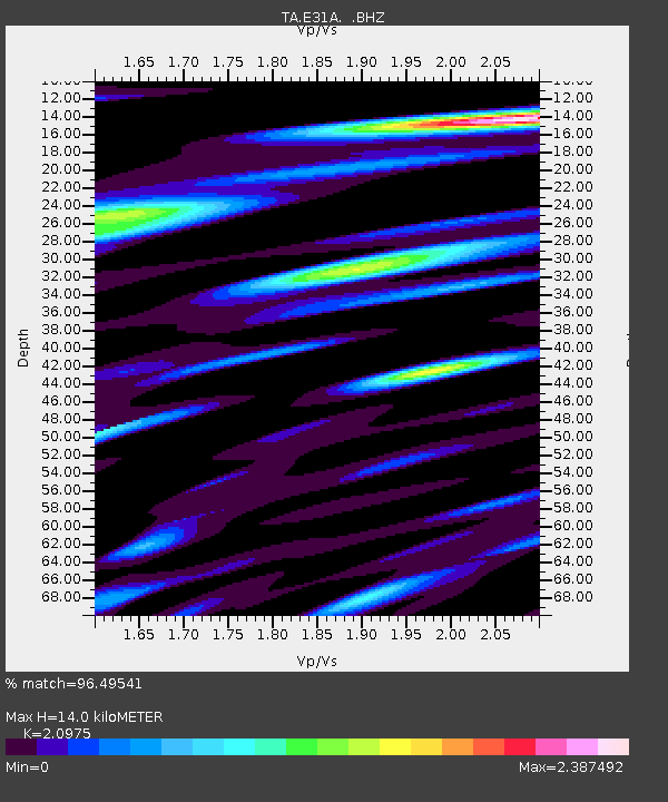
E31A Nome, ND, USA - Earthquake Result Viewer
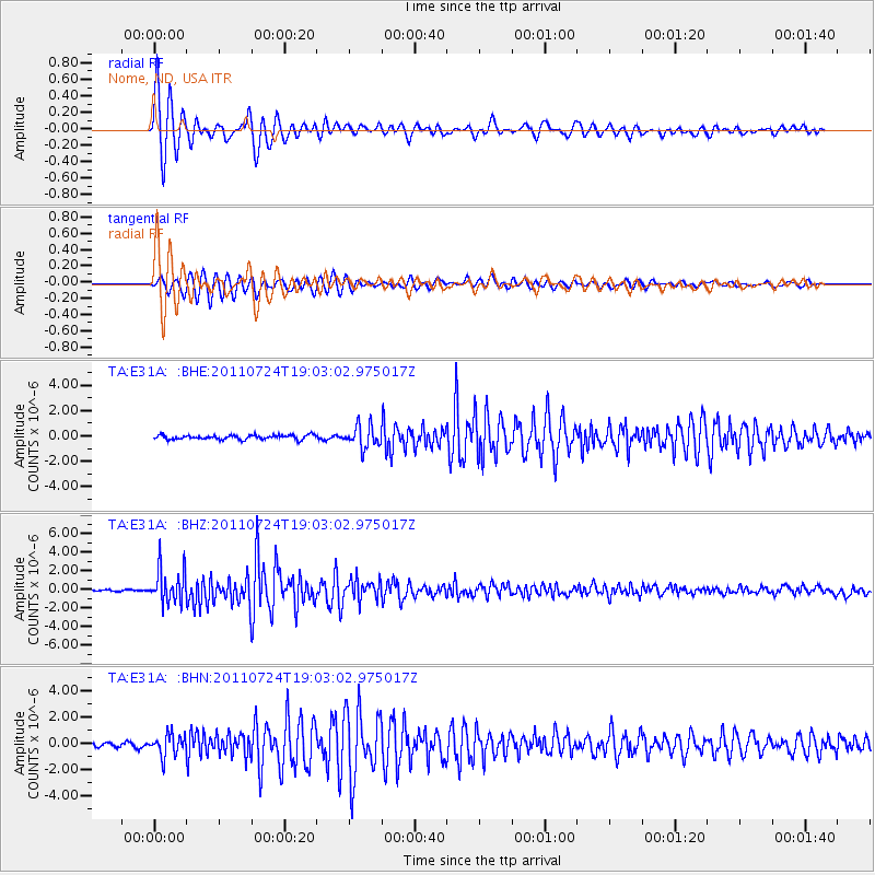
Earthquake location: Near East Coast Of Honshu, Japan
Earthquake latitude/longitude: 37.7/141.4
Earthquake time(UTC): 2011/07/24 (205) 18:51:24 GMT
Earthquake Depth: 35 km
Earthquake Magnitude: 6.3 MB, 5.9 MS, 6.3 MW, 6.3 MW
Earthquake Catalog/Contributor: WHDF/NEIC
Network: TA USArray Transportable Network (new EarthScope stations)
Station: E31A Nome, ND, USA
Lat/Lon: 46.56 N/97.89 W
Elevation: 427 m
Distance: 80.7 deg
Az: 36.95 deg
Baz: 316.312 deg
Ray Param: 0.048047323
Estimated Moho Depth: 14.0 km
Estimated Crust Vp/Vs: 2.10
Assumed Crust Vp: 6.498 km/s
Estimated Crust Vs: 3.098 km/s
Estimated Crust Poisson's Ratio: 0.35
Radial Match: 96.49541 %
Radial Bump: 363
Transverse Match: 93.84923 %
Transverse Bump: 400
SOD ConfigId: 405110
Insert Time: 2011-12-29 06:09:38.696 +0000
GWidth: 2.5
Max Bumps: 400
Tol: 0.001

Signal To Noise

ChannelStoNSTALTA
TA:E31A: :BHZ:20110724T19:03:02.975017Z21.189121.8219673E-68.598598E-8
TA:E31A: :BHN:20110724T19:03:02.975017Z4.3042188.1687887E-71.8978567E-7
TA:E31A: :BHE:20110724T19:03:02.975017Z5.05171738.505226E-71.6836306E-7
Arrivals
Ps2.4 SECOND
PpPs6.5 SECOND
PsPs/PpSs8.9 SECOND