K31A O'Neill, NE, USA - Earthquake Result Viewer
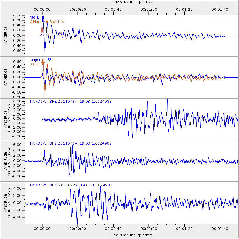
Earthquake location: Near East Coast Of Honshu, Japan
Earthquake latitude/longitude: 37.7/141.4
Earthquake time(UTC): 2011/07/24 (205) 18:51:24 GMT
Earthquake Depth: 35 km
Earthquake Magnitude: 6.3 MB, 5.9 MS, 6.3 MW, 6.3 MW
Earthquake Catalog/Contributor: WHDF/NEIC
Network: TA USArray Transportable Network (new EarthScope stations)
Station: K31A O'Neill, NE, USA
Lat/Lon: 42.62 N/98.75 W
Elevation: 580 m
Distance: 83.1 deg
Az: 40.151 deg
Baz: 316.156 deg
Ray Param: 0.04636667
Estimated Moho Depth: 20.0 km
Estimated Crust Vp/Vs: 1.92
Assumed Crust Vp: 6.53 km/s
Estimated Crust Vs: 3.401 km/s
Estimated Crust Poisson's Ratio: 0.31
Radial Match: 95.73121 %
Radial Bump: 400
Transverse Match: 93.197784 %
Transverse Bump: 400
SOD ConfigId: 405110
Insert Time: 2011-12-29 06:09:58.820 +0000
GWidth: 2.5
Max Bumps: 400
Tol: 0.001

Signal To Noise

ChannelStoNSTALTA
TA:K31A: :BHZ:20110724T19:03:15.62498Z13.9236581.2866018E-69.240401E-8
TA:K31A: :BHN:20110724T19:03:15.62498Z5.97921941.0724095E-61.793561E-7
TA:K31A: :BHE:20110724T19:03:15.62498Z2.87305245.1725635E-71.800372E-7
Arrivals
Ps2.9 SECOND
PpPs8.7 SECOND
PsPs/PpSs12 SECOND