You are here: Home > Network List > TA - USArray Transportable Network (new EarthScope stations) Stations List
> Station F33A 5 Mile Ranch, Herman, MN, USA > Earthquake Result Viewer
F33A 5 Mile Ranch, Herman, MN, USA - Earthquake Result Viewer

| Earthquake location: |
Near East Coast Of Honshu, Japan |
| Earthquake latitude/longitude: |
37.7/141.4 |
| Earthquake time(UTC): |
2011/07/24 (205) 18:51:24 GMT |
| Earthquake Depth: |
35 km |
| Earthquake Magnitude: |
6.3 MB, 5.9 MS, 6.3 MW, 6.3 MW |
| Earthquake Catalog/Contributor: |
WHDF/NEIC |
|
| Network: |
TA USArray Transportable Network (new EarthScope stations) |
| Station: |
F33A 5 Mile Ranch, Herman, MN, USA |
| Lat/Lon: |
45.84 N/96.29 W |
| Elevation: |
313 m |
|
| Distance: |
82.0 deg |
| Az: |
36.63 deg |
| Baz: |
317.411 deg |
| Ray Param: |
0.047151987 |
| Estimated Moho Depth: |
40.5 km |
| Estimated Crust Vp/Vs: |
1.67 |
| Assumed Crust Vp: |
6.552 km/s |
| Estimated Crust Vs: |
3.929 km/s |
| Estimated Crust Poisson's Ratio: |
0.22 |
|
| Radial Match: |
92.9707 % |
| Radial Bump: |
376 |
| Transverse Match: |
74.89838 % |
| Transverse Bump: |
400 |
| SOD ConfigId: |
405110 |
| Insert Time: |
2011-12-29 06:10:04.487 +0000 |
| GWidth: |
2.5 |
| Max Bumps: |
400 |
| Tol: |
0.001 |
|
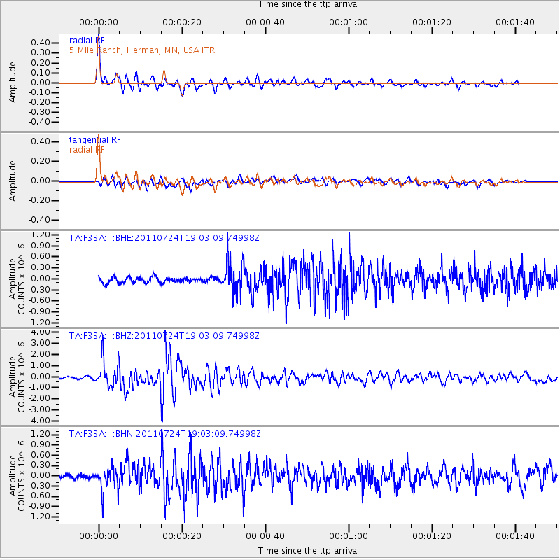
Signal To Noise
| Channel | StoN | STA | LTA |
| TA:F33A: :BHZ:20110724T19:03:09.74998Z | 13.731805 | 1.2062807E-6 | 8.7845756E-8 |
| TA:F33A: :BHN:20110724T19:03:09.74998Z | 3.1882648 | 3.305186E-7 | 1.0366723E-7 |
| TA:F33A: :BHE:20110724T19:03:09.74998Z | 5.880738 | 4.381804E-7 | 7.451113E-8 |
| Arrivals |
| Ps | 4.2 SECOND |
| PpPs | 16 SECOND |
| PsPs/PpSs | 20 SECOND |


