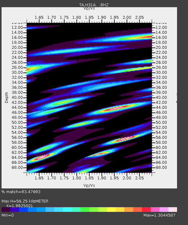
H31A Wolsey, SD, USA - Earthquake Result Viewer

Earthquake location: Near East Coast Of Honshu, Japan
Earthquake latitude/longitude: 37.7/141.4
Earthquake time(UTC): 2011/07/24 (205) 18:51:24 GMT
Earthquake Depth: 35 km
Earthquake Magnitude: 6.3 MB, 5.9 MS, 6.3 MW, 6.3 MW
Earthquake Catalog/Contributor: WHDF/NEIC
Network: TA USArray Transportable Network (new EarthScope stations)
Station: H31A Wolsey, SD, USA
Lat/Lon: 44.48 N/98.48 W
Elevation: 415 m
Distance: 81.9 deg
Az: 38.708 deg
Baz: 316.158 deg
Ray Param: 0.047199007
Estimated Moho Depth: 56.25 km
Estimated Crust Vp/Vs: 1.99
Assumed Crust Vp: 6.53 km/s
Estimated Crust Vs: 3.278 km/s
Estimated Crust Poisson's Ratio: 0.33
Radial Match: 93.47693 %
Radial Bump: 400
Transverse Match: 86.74845 %
Transverse Bump: 400
SOD ConfigId: 405110
Insert Time: 2011-12-29 06:10:12.412 +0000
GWidth: 2.5
Max Bumps: 400
Tol: 0.001

Signal To Noise

ChannelStoNSTALTA
TA:H31A: :BHZ:20110724T19:03:09.400005Z3.95515631.1716207E-62.9622615E-7
TA:H31A: :BHN:20110724T19:03:09.400005Z1.54903544.6850934E-73.024523E-7
TA:H31A: :BHE:20110724T19:03:09.400005Z2.22676046.717971E-73.016926E-7
Arrivals
Ps8.8 SECOND
PpPs25 SECOND
PsPs/PpSs34 SECOND