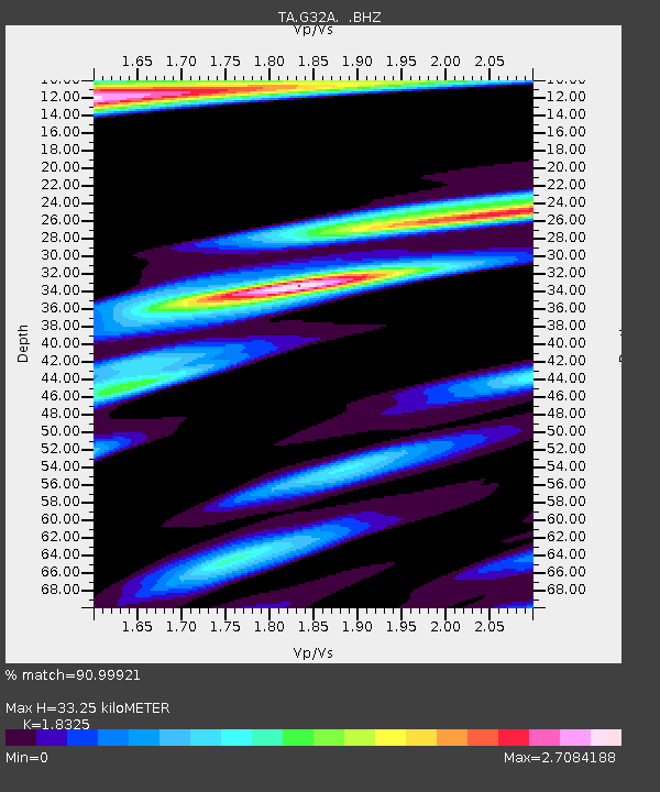
G32A Webster, SD, USA - Earthquake Result Viewer

Earthquake location: Near East Coast Of Honshu, Japan
Earthquake latitude/longitude: 37.7/141.4
Earthquake time(UTC): 2011/07/24 (205) 18:51:24 GMT
Earthquake Depth: 35 km
Earthquake Magnitude: 6.3 MB, 5.9 MS, 6.3 MW, 6.3 MW
Earthquake Catalog/Contributor: WHDF/NEIC
Network: TA USArray Transportable Network (new EarthScope stations)
Station: G32A Webster, SD, USA
Lat/Lon: 45.26 N/97.50 W
Elevation: 566 m
Distance: 81.8 deg
Az: 37.658 deg
Baz: 316.697 deg
Ray Param: 0.047257204
Estimated Moho Depth: 33.25 km
Estimated Crust Vp/Vs: 1.83
Assumed Crust Vp: 6.552 km/s
Estimated Crust Vs: 3.576 km/s
Estimated Crust Poisson's Ratio: 0.29
Radial Match: 90.99921 %
Radial Bump: 400
Transverse Match: 75.22763 %
Transverse Bump: 400
SOD ConfigId: 405110
Insert Time: 2011-12-29 06:11:31.243 +0000
GWidth: 2.5
Max Bumps: 400
Tol: 0.001

Signal To Noise

ChannelStoNSTALTA
TA:G32A: :BHZ:20110724T19:03:08.949993Z19.1752551.9265658E-61.0047147E-7
TA:G32A: :BHN:20110724T19:03:08.949993Z2.03081567.674184E-73.778868E-7
TA:G32A: :BHE:20110724T19:03:08.949993Z1.50672277.5676076E-75.0225617E-7
Arrivals
Ps4.3 SECOND
PpPs14 SECOND
PsPs/PpSs18 SECOND