F32A Veblen, SD, USA - Earthquake Result Viewer
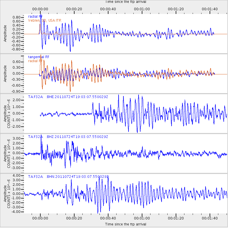
Earthquake location: Near East Coast Of Honshu, Japan
Earthquake latitude/longitude: 37.7/141.4
Earthquake time(UTC): 2011/07/24 (205) 18:51:24 GMT
Earthquake Depth: 35 km
Earthquake Magnitude: 6.3 MB, 5.9 MS, 6.3 MW, 6.3 MW
Earthquake Catalog/Contributor: WHDF/NEIC
Network: TA USArray Transportable Network (new EarthScope stations)
Station: F32A Veblen, SD, USA
Lat/Lon: 45.87 N/97.13 W
Elevation: 371 m
Distance: 81.6 deg
Az: 37.04 deg
Baz: 316.874 deg
Ray Param: 0.047445912
Estimated Moho Depth: 30.5 km
Estimated Crust Vp/Vs: 1.94
Assumed Crust Vp: 6.552 km/s
Estimated Crust Vs: 3.382 km/s
Estimated Crust Poisson's Ratio: 0.32
Radial Match: 90.283394 %
Radial Bump: 400
Transverse Match: 84.88353 %
Transverse Bump: 400
SOD ConfigId: 405110
Insert Time: 2011-12-29 06:14:27.430 +0000
GWidth: 2.5
Max Bumps: 400
Tol: 0.001

Signal To Noise

ChannelStoNSTALTA
TA:F32A: :BHZ:20110724T19:03:07.550029Z11.0270451.0987404E-69.964051E-8
TA:F32A: :BHN:20110724T19:03:07.550029Z2.99477244.7982337E-71.6022031E-7
TA:F32A: :BHE:20110724T19:03:07.550029Z4.82728866.467689E-71.3398181E-7
Arrivals
Ps4.5 SECOND
PpPs13 SECOND
PsPs/PpSs18 SECOND