You are here: Home > Network List > G - GEOSCOPE Stations List
> Station CAN Canberra, Australia > Earthquake Result Viewer
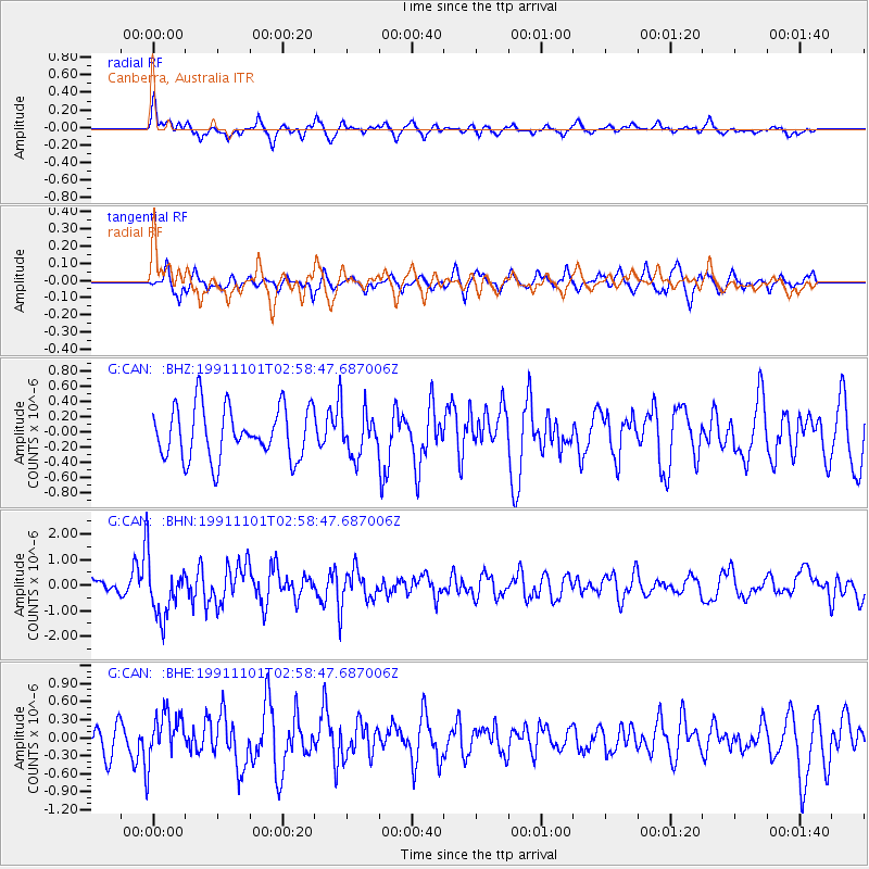
CAN Canberra, Australia - Earthquake Result Viewer
*The percent match for this event was below the threshold and hence no stack was calculated.
| Earthquake location: |
Minahassa Peninsula, Sulawesi |
| Earthquake latitude/longitude: |
1.2/122.1 |
| Earthquake time(UTC): |
1991/11/01 (305) 02:51:12 GMT |
| Earthquake Depth: |
38 km |
| Earthquake Magnitude: |
5.5 MB, 5.6 MS |
| Earthquake Catalog/Contributor: |
WHDF/NEIC |
|
| Network: |
G GEOSCOPE |
| Station: |
CAN Canberra, Australia |
| Lat/Lon: |
35.32 S/149.00 E |
| Elevation: |
650 m |
|
| Distance: |
44.2 deg |
| Az: |
147.954 deg |
| Baz: |
319.557 deg |
| Ray Param: |
$rayparam |
*The percent match for this event was below the threshold and hence was not used in the summary stack. |
|
| Radial Match: |
76.468056 % |
| Radial Bump: |
400 |
| Transverse Match: |
57.217937 % |
| Transverse Bump: |
325 |
| SOD ConfigId: |
4480 |
| Insert Time: |
2010-02-26 21:49:32.914 +0000 |
| GWidth: |
2.5 |
| Max Bumps: |
400 |
| Tol: |
0.001 |
|
Signal To Noise
| Channel | StoN | STA | LTA |
| G:CAN: :BHN:19911101T02:58:47.687006Z | 3.2832835 | 1.0787217E-6 | 3.2854965E-7 |
| G:CAN: :BHE:19911101T02:58:47.687006Z | 1.6651987 | 3.971173E-7 | 2.3848042E-7 |
| G:CAN: :BHZ:19911101T02:58:47.687006Z | 0.88456696 | 2.9807381E-7 | 3.3697145E-7 |
| Arrivals |
| Ps | |
| PpPs | |
| PsPs/PpSs | |


