S40A Lebanon, MO, USA - Earthquake Result Viewer
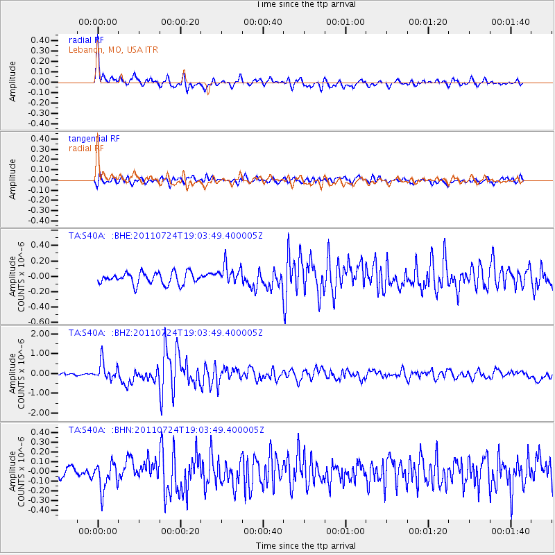
Earthquake location: Near East Coast Of Honshu, Japan
Earthquake latitude/longitude: 37.7/141.4
Earthquake time(UTC): 2011/07/24 (205) 18:51:24 GMT
Earthquake Depth: 35 km
Earthquake Magnitude: 6.3 MB, 5.9 MS, 6.3 MW, 6.3 MW
Earthquake Catalog/Contributor: WHDF/NEIC
Network: TA USArray Transportable Network (new EarthScope stations)
Station: S40A Lebanon, MO, USA
Lat/Lon: 37.60 N/92.50 W
Elevation: 336 m
Distance: 90.1 deg
Az: 39.921 deg
Baz: 320.161 deg
Ray Param: 0.041696534
Estimated Moho Depth: 52.5 km
Estimated Crust Vp/Vs: 1.64
Assumed Crust Vp: 6.53 km/s
Estimated Crust Vs: 3.97 km/s
Estimated Crust Poisson's Ratio: 0.21
Radial Match: 85.64789 %
Radial Bump: 400
Transverse Match: 75.44455 %
Transverse Bump: 400
SOD ConfigId: 405110
Insert Time: 2011-12-29 06:17:13.580 +0000
GWidth: 2.5
Max Bumps: 400
Tol: 0.001

Signal To Noise

ChannelStoNSTALTA
TA:S40A: :BHZ:20110724T19:03:49.400005Z7.7484734.745348E-76.124236E-8
TA:S40A: :BHN:20110724T19:03:49.400005Z3.81430321.4513436E-73.8050032E-8
TA:S40A: :BHE:20110724T19:03:49.400005Z1.71223681.283165E-77.4940864E-8
Arrivals
Ps5.3 SECOND
PpPs21 SECOND
PsPs/PpSs26 SECOND