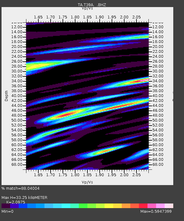
T39A Clever, MO, USA - Earthquake Result Viewer

Earthquake location: Near East Coast Of Honshu, Japan
Earthquake latitude/longitude: 37.7/141.4
Earthquake time(UTC): 2011/07/24 (205) 18:51:24 GMT
Earthquake Depth: 35 km
Earthquake Magnitude: 6.3 MB, 5.9 MS, 6.3 MW, 6.3 MW
Earthquake Catalog/Contributor: WHDF/NEIC
Network: TA USArray Transportable Network (new EarthScope stations)
Station: T39A Clever, MO, USA
Lat/Lon: 37.02 N/93.38 W
Elevation: 366 m
Distance: 90.0 deg
Az: 40.825 deg
Baz: 319.631 deg
Ray Param: 0.041697327
Estimated Moho Depth: 33.25 km
Estimated Crust Vp/Vs: 2.10
Assumed Crust Vp: 6.53 km/s
Estimated Crust Vs: 3.113 km/s
Estimated Crust Poisson's Ratio: 0.35
Radial Match: 88.04004 %
Radial Bump: 400
Transverse Match: 74.21073 %
Transverse Bump: 400
SOD ConfigId: 405110
Insert Time: 2011-12-29 06:17:33.452 +0000
GWidth: 2.5
Max Bumps: 400
Tol: 0.001

Signal To Noise

ChannelStoNSTALTA
TA:T39A: :BHZ:20110724T19:03:49.350017Z7.0020465.3755684E-77.6771386E-8
TA:T39A: :BHN:20110724T19:03:49.350017Z2.1837531.7878388E-78.1870006E-8
TA:T39A: :BHE:20110724T19:03:49.350017Z1.47999511.1383912E-77.6918575E-8
Arrivals
Ps5.7 SECOND
PpPs15 SECOND
PsPs/PpSs21 SECOND