You are here: Home > Network List > TA - USArray Transportable Network (new EarthScope stations) Stations List
> Station X39A Fountain Ranch, Mena, AR, USA > Earthquake Result Viewer
X39A Fountain Ranch, Mena, AR, USA - Earthquake Result Viewer
| Earthquake location: |
Near East Coast Of Honshu, Japan |
| Earthquake latitude/longitude: |
37.7/141.4 |
| Earthquake time(UTC): |
2011/07/24 (205) 18:51:24 GMT |
| Earthquake Depth: |
35 km |
| Earthquake Magnitude: |
6.3 MB, 5.9 MS, 6.3 MW, 6.3 MW |
| Earthquake Catalog/Contributor: |
WHDF/NEIC |
|
| Network: |
TA USArray Transportable Network (new EarthScope stations) |
| Station: |
X39A Fountain Ranch, Mena, AR, USA |
| Lat/Lon: |
34.51 N/94.11 W |
| Elevation: |
326 m |
|
| Distance: |
91.6 deg |
| Az: |
42.912 deg |
| Baz: |
319.174 deg |
| Ray Param: |
0.041582644 |
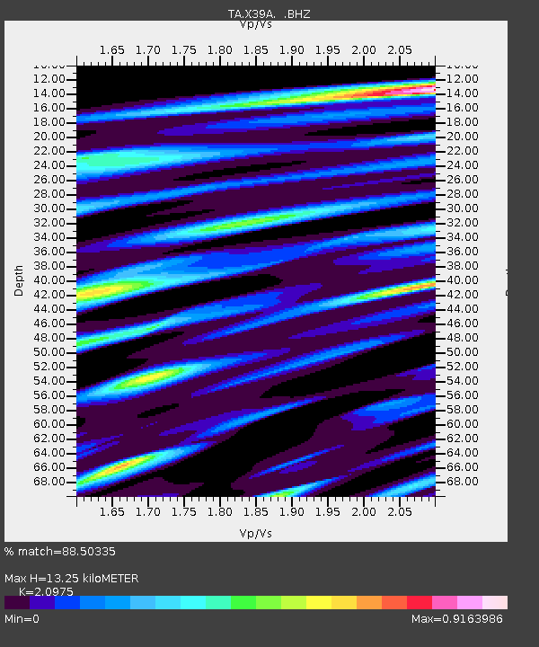
| Estimated Moho Depth: |
13.25 km |
| Estimated Crust Vp/Vs: |
2.10 |
| Assumed Crust Vp: |
6.498 km/s |
| Estimated Crust Vs: |
3.098 km/s |
| Estimated Crust Poisson's Ratio: |
0.35 |
|
| Radial Match: |
88.50335 % |
| Radial Bump: |
400 |
| Transverse Match: |
68.73679 % |
| Transverse Bump: |
400 |
| SOD ConfigId: |
405110 |
| Insert Time: |
2011-12-29 06:17:59.048 +0000 |
| GWidth: |
2.5 |
| Max Bumps: |
400 |
| Tol: |
0.001 |
|
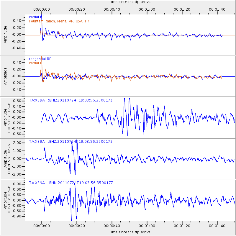
Signal To Noise
| Channel | StoN | STA | LTA |
| TA:X39A: :BHZ:20110724T19:03:56.350017Z | 5.194378 | 4.4235554E-7 | 8.5160444E-8 |
| TA:X39A: :BHN:20110724T19:03:56.350017Z | 2.6891716 | 1.7554098E-7 | 6.527697E-8 |
| TA:X39A: :BHE:20110724T19:03:56.350017Z | 1.4909827 | 1.2645948E-7 | 8.48162E-8 |
| Arrivals |
| Ps | 2.3 SECOND |
| PpPs | 6.2 SECOND |
| PsPs/PpSs | 8.5 SECOND |


