You are here: Home > Network List > TA - USArray Transportable Network (new EarthScope stations) Stations List
> Station Y46A Houston, MS, USA > Earthquake Result Viewer
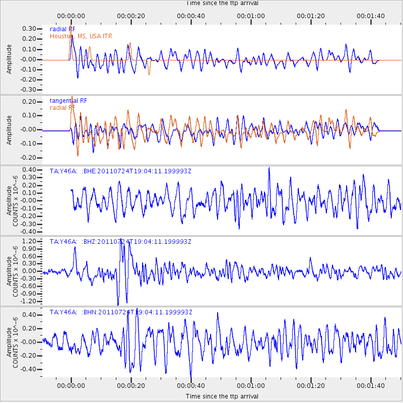
Y46A Houston, MS, USA - Earthquake Result Viewer
*The percent match for this event was below the threshold and hence no stack was calculated.
| Earthquake location: |
Near East Coast Of Honshu, Japan |
| Earthquake latitude/longitude: |
37.7/141.4 |
| Earthquake time(UTC): |
2011/07/24 (205) 18:51:24 GMT |
| Earthquake Depth: |
35 km |
| Earthquake Magnitude: |
6.3 MB, 5.9 MS, 6.3 MW, 6.3 MW |
| Earthquake Catalog/Contributor: |
WHDF/NEIC |
|
| Network: |
TA USArray Transportable Network (new EarthScope stations) |
| Station: |
Y46A Houston, MS, USA |
| Lat/Lon: |
33.88 N/88.86 W |
| Elevation: |
109 m |
|
| Distance: |
94.8 deg |
| Az: |
39.931 deg |
| Baz: |
322.281 deg |
| Ray Param: |
$rayparam |
*The percent match for this event was below the threshold and hence was not used in the summary stack. |
|
| Radial Match: |
71.14595 % |
| Radial Bump: |
400 |
| Transverse Match: |
75.01459 % |
| Transverse Bump: |
400 |
| SOD ConfigId: |
405110 |
| Insert Time: |
2011-12-29 06:21:06.008 +0000 |
| GWidth: |
2.5 |
| Max Bumps: |
400 |
| Tol: |
0.001 |
|
Signal To Noise
| Channel | StoN | STA | LTA |
| TA:Y46A: :BHZ:20110724T19:04:11.199993Z | 3.5742722 | 3.449271E-7 | 9.6502745E-8 |
| TA:Y46A: :BHN:20110724T19:04:11.199993Z | 1.0339627 | 9.441772E-8 | 9.131637E-8 |
| TA:Y46A: :BHE:20110724T19:04:11.199993Z | 0.8726722 | 1.02482595E-7 | 1.17435384E-7 |
| Arrivals |
| Ps | |
| PpPs | |
| PsPs/PpSs | |


