You are here: Home > Network List > TA - USArray Transportable Network (new EarthScope stations) Stations List
> Station Z44A Pea Ridge, Belzoni, MS, USA > Earthquake Result Viewer
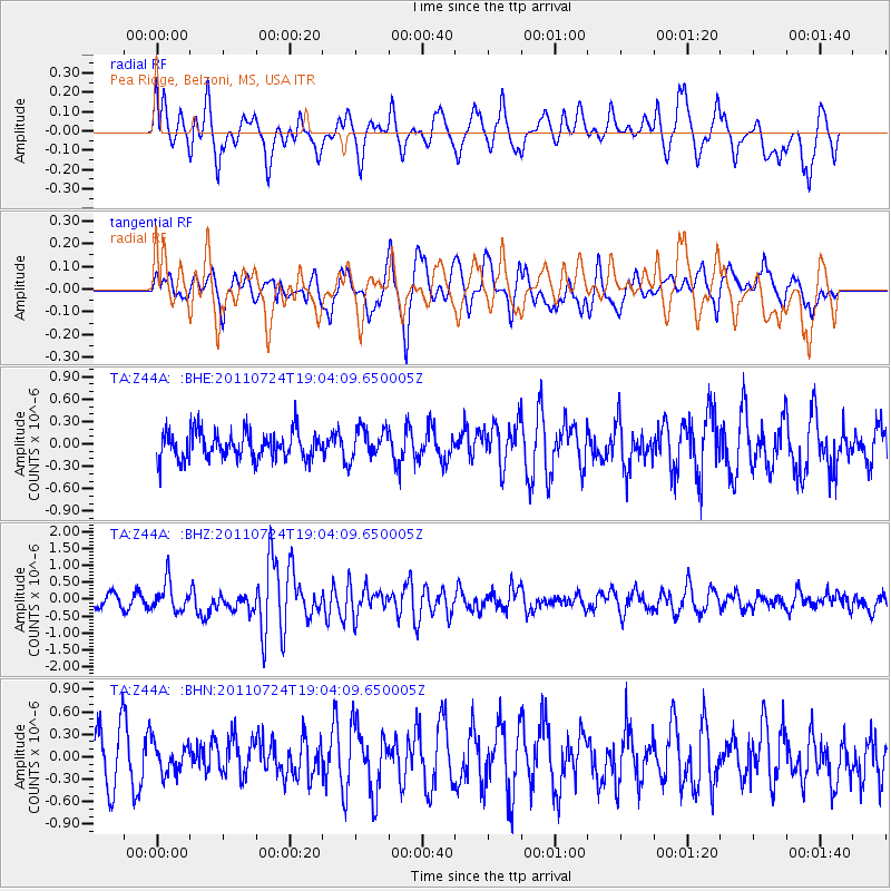
Z44A Pea Ridge, Belzoni, MS, USA - Earthquake Result Viewer
*The percent match for this event was below the threshold and hence no stack was calculated.
| Earthquake location: |
Near East Coast Of Honshu, Japan |
| Earthquake latitude/longitude: |
37.7/141.4 |
| Earthquake time(UTC): |
2011/07/24 (205) 18:51:24 GMT |
| Earthquake Depth: |
35 km |
| Earthquake Magnitude: |
6.3 MB, 5.9 MS, 6.3 MW, 6.3 MW |
| Earthquake Catalog/Contributor: |
WHDF/NEIC |
|
| Network: |
TA USArray Transportable Network (new EarthScope stations) |
| Station: |
Z44A Pea Ridge, Belzoni, MS, USA |
| Lat/Lon: |
33.28 N/90.43 W |
| Elevation: |
39 m |
|
| Distance: |
94.5 deg |
| Az: |
41.342 deg |
| Baz: |
321.3 deg |
| Ray Param: |
$rayparam |
*The percent match for this event was below the threshold and hence was not used in the summary stack. |
|
| Radial Match: |
72.09398 % |
| Radial Bump: |
400 |
| Transverse Match: |
63.495895 % |
| Transverse Bump: |
400 |
| SOD ConfigId: |
405110 |
| Insert Time: |
2011-12-29 06:21:19.153 +0000 |
| GWidth: |
2.5 |
| Max Bumps: |
400 |
| Tol: |
0.001 |
|
Signal To Noise
| Channel | StoN | STA | LTA |
| TA:Z44A: :BHZ:20110724T19:04:09.650005Z | 2.553449 | 4.3523363E-7 | 1.7044933E-7 |
| TA:Z44A: :BHN:20110724T19:04:09.650005Z | 0.5446147 | 1.919735E-7 | 3.5249414E-7 |
| TA:Z44A: :BHE:20110724T19:04:09.650005Z | 1.0879672 | 2.015249E-7 | 1.8523068E-7 |
| Arrivals |
| Ps | |
| PpPs | |
| PsPs/PpSs | |


