You are here: Home > Network List > TA - USArray Transportable Network (new EarthScope stations) Stations List
> Station Z48A Northport, AL, USA > Earthquake Result Viewer
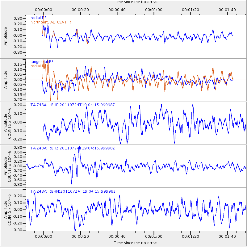
Z48A Northport, AL, USA - Earthquake Result Viewer
*The percent match for this event was below the threshold and hence no stack was calculated.
| Earthquake location: |
Near East Coast Of Honshu, Japan |
| Earthquake latitude/longitude: |
37.7/141.4 |
| Earthquake time(UTC): |
2011/07/24 (205) 18:51:24 GMT |
| Earthquake Depth: |
35 km |
| Earthquake Magnitude: |
6.3 MB, 5.9 MS, 6.3 MW, 6.3 MW |
| Earthquake Catalog/Contributor: |
WHDF/NEIC |
|
| Network: |
TA USArray Transportable Network (new EarthScope stations) |
| Station: |
Z48A Northport, AL, USA |
| Lat/Lon: |
33.38 N/87.56 W |
| Elevation: |
101 m |
|
| Distance: |
95.9 deg |
| Az: |
39.371 deg |
| Baz: |
323.051 deg |
| Ray Param: |
$rayparam |
*The percent match for this event was below the threshold and hence was not used in the summary stack. |
|
| Radial Match: |
54.08382 % |
| Radial Bump: |
400 |
| Transverse Match: |
60.00534 % |
| Transverse Bump: |
400 |
| SOD ConfigId: |
405110 |
| Insert Time: |
2011-12-29 06:21:32.159 +0000 |
| GWidth: |
2.5 |
| Max Bumps: |
400 |
| Tol: |
0.001 |
|
Signal To Noise
| Channel | StoN | STA | LTA |
| TA:Z48A: :BHZ:20110724T19:04:15.99998Z | 1.9761437 | 1.5669382E-7 | 7.9292725E-8 |
| TA:Z48A: :BHN:20110724T19:04:15.99998Z | 0.76230365 | 5.5545982E-8 | 7.286595E-8 |
| TA:Z48A: :BHE:20110724T19:04:15.99998Z | 1.6750228 | 1.2410928E-7 | 7.409408E-8 |
| Arrivals |
| Ps | |
| PpPs | |
| PsPs/PpSs | |


