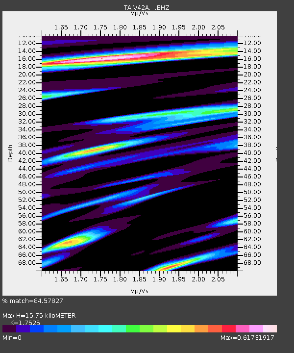
V42A Cord, AR, USA - Earthquake Result Viewer

Earthquake location: Near East Coast Of Honshu, Japan
Earthquake latitude/longitude: 37.7/141.4
Earthquake time(UTC): 2011/07/24 (205) 18:51:24 GMT
Earthquake Depth: 35 km
Earthquake Magnitude: 6.3 MB, 5.9 MS, 6.3 MW, 6.3 MW
Earthquake Catalog/Contributor: WHDF/NEIC
Network: TA USArray Transportable Network (new EarthScope stations)
Station: V42A Cord, AR, USA
Lat/Lon: 35.81 N/91.39 W
Elevation: 134 m
Distance: 92.0 deg
Az: 40.37 deg
Baz: 320.814 deg
Ray Param: 0.041515205
Estimated Moho Depth: 15.75 km
Estimated Crust Vp/Vs: 1.75
Assumed Crust Vp: 6.273 km/s
Estimated Crust Vs: 3.58 km/s
Estimated Crust Poisson's Ratio: 0.26
Radial Match: 84.57827 %
Radial Bump: 400
Transverse Match: 66.045944 %
Transverse Bump: 400
SOD ConfigId: 405110
Insert Time: 2011-12-29 06:22:23.705 +0000
GWidth: 2.5
Max Bumps: 400
Tol: 0.001

Signal To Noise

ChannelStoNSTALTA
TA:V42A: :BHZ:20110724T19:03:58.400005Z4.5237123.4068026E-77.530989E-8
TA:V42A: :BHN:20110724T19:03:58.400005Z1.64490251.3513923E-78.2156376E-8
TA:V42A: :BHE:20110724T19:03:58.400005Z2.13500861.6082465E-77.53274E-8
Arrivals
Ps1.9 SECOND
PpPs6.8 SECOND
PsPs/PpSs8.7 SECOND