You are here: Home > Network List > TA - USArray Transportable Network (new EarthScope stations) Stations List
> Station V45A Humboldt, TN, USA > Earthquake Result Viewer
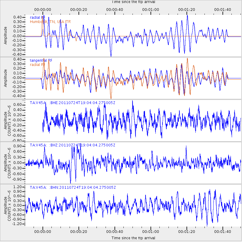
V45A Humboldt, TN, USA - Earthquake Result Viewer
*The percent match for this event was below the threshold and hence no stack was calculated.
| Earthquake location: |
Near East Coast Of Honshu, Japan |
| Earthquake latitude/longitude: |
37.7/141.4 |
| Earthquake time(UTC): |
2011/07/24 (205) 18:51:24 GMT |
| Earthquake Depth: |
35 km |
| Earthquake Magnitude: |
6.3 MB, 5.9 MS, 6.3 MW, 6.3 MW |
| Earthquake Catalog/Contributor: |
WHDF/NEIC |
|
| Network: |
TA USArray Transportable Network (new EarthScope stations) |
| Station: |
V45A Humboldt, TN, USA |
| Lat/Lon: |
35.74 N/88.96 W |
| Elevation: |
126 m |
|
| Distance: |
93.3 deg |
| Az: |
38.861 deg |
| Baz: |
322.299 deg |
| Ray Param: |
$rayparam |
*The percent match for this event was below the threshold and hence was not used in the summary stack. |
|
| Radial Match: |
58.385616 % |
| Radial Bump: |
400 |
| Transverse Match: |
60.23878 % |
| Transverse Bump: |
380 |
| SOD ConfigId: |
405110 |
| Insert Time: |
2011-12-29 06:22:36.924 +0000 |
| GWidth: |
2.5 |
| Max Bumps: |
400 |
| Tol: |
0.001 |
|
Signal To Noise
| Channel | StoN | STA | LTA |
| TA:V45A: :BHZ:20110724T19:04:04.275005Z | 2.8068547 | 3.030342E-7 | 1.07962194E-7 |
| TA:V45A: :BHN:20110724T19:04:04.275005Z | 1.1563061 | 3.3148E-7 | 2.8667148E-7 |
| TA:V45A: :BHE:20110724T19:04:04.275005Z | 1.6327691 | 3.480749E-7 | 2.1318073E-7 |
| Arrivals |
| Ps | |
| PpPs | |
| PsPs/PpSs | |


