You are here: Home > Network List > TA - USArray Transportable Network (new EarthScope stations) Stations List
> Station Q44A Meyer Farm, Vandalia, IL, USA > Earthquake Result Viewer
Q44A Meyer Farm, Vandalia, IL, USA - Earthquake Result Viewer
| Earthquake location: |
Near East Coast Of Honshu, Japan |
| Earthquake latitude/longitude: |
37.7/141.4 |
| Earthquake time(UTC): |
2011/07/24 (205) 18:51:24 GMT |
| Earthquake Depth: |
35 km |
| Earthquake Magnitude: |
6.3 MB, 5.9 MS, 6.3 MW, 6.3 MW |
| Earthquake Catalog/Contributor: |
WHDF/NEIC |
|
| Network: |
TA USArray Transportable Network (new EarthScope stations) |
| Station: |
Q44A Meyer Farm, Vandalia, IL, USA |
| Lat/Lon: |
38.90 N/89.02 W |
| Elevation: |
164 m |
|
| Distance: |
90.8 deg |
| Az: |
36.967 deg |
| Baz: |
322.331 deg |
| Ray Param: |
0.04164646 |
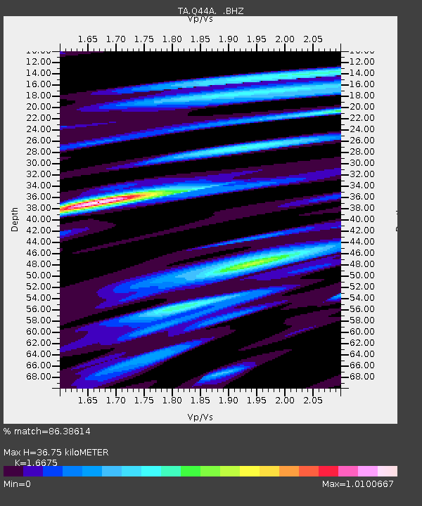
| Estimated Moho Depth: |
36.75 km |
| Estimated Crust Vp/Vs: |
1.67 |
| Assumed Crust Vp: |
6.444 km/s |
| Estimated Crust Vs: |
3.864 km/s |
| Estimated Crust Poisson's Ratio: |
0.22 |
|
| Radial Match: |
86.38614 % |
| Radial Bump: |
400 |
| Transverse Match: |
76.472565 % |
| Transverse Bump: |
400 |
| SOD ConfigId: |
405110 |
| Insert Time: |
2011-12-29 06:23:30.012 +0000 |
| GWidth: |
2.5 |
| Max Bumps: |
400 |
| Tol: |
0.001 |
|
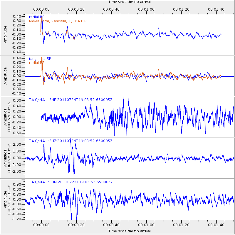
Signal To Noise
| Channel | StoN | STA | LTA |
| TA:Q44A: :BHZ:20110724T19:03:52.650005Z | 7.0980425 | 6.9551635E-7 | 9.798706E-8 |
| TA:Q44A: :BHN:20110724T19:03:52.650005Z | 2.1317618 | 2.2559996E-7 | 1.05827944E-7 |
| TA:Q44A: :BHE:20110724T19:03:52.650005Z | 2.3498294 | 1.9349146E-7 | 8.234277E-8 |
| Arrivals |
| Ps | 3.9 SECOND |
| PpPs | 15 SECOND |
| PsPs/PpSs | 19 SECOND |


