You are here: Home > Network List > TA - USArray Transportable Network (new EarthScope stations) Stations List
> Station O41A Passley's Farm, La Prairie, IL, USA > Earthquake Result Viewer
O41A Passley's Farm, La Prairie, IL, USA - Earthquake Result Viewer
| Earthquake location: |
Near East Coast Of Honshu, Japan |
| Earthquake latitude/longitude: |
37.7/141.4 |
| Earthquake time(UTC): |
2011/07/24 (205) 18:51:24 GMT |
| Earthquake Depth: |
35 km |
| Earthquake Magnitude: |
6.3 MB, 5.9 MS, 6.3 MW, 6.3 MW |
| Earthquake Catalog/Contributor: |
WHDF/NEIC |
|
| Network: |
TA USArray Transportable Network (new EarthScope stations) |
| Station: |
O41A Passley's Farm, La Prairie, IL, USA |
| Lat/Lon: |
40.12 N/90.88 W |
| Elevation: |
203 m |
|
| Distance: |
88.9 deg |
| Az: |
37.35 deg |
| Baz: |
321.15 deg |
| Ray Param: |
0.04218973 |
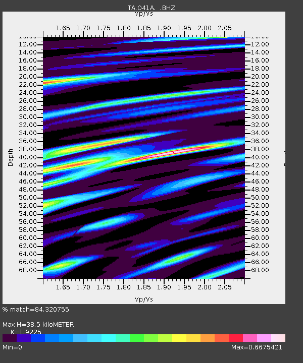
| Estimated Moho Depth: |
38.5 km |
| Estimated Crust Vp/Vs: |
1.92 |
| Assumed Crust Vp: |
6.498 km/s |
| Estimated Crust Vs: |
3.38 km/s |
| Estimated Crust Poisson's Ratio: |
0.31 |
|
| Radial Match: |
84.320755 % |
| Radial Bump: |
400 |
| Transverse Match: |
72.81844 % |
| Transverse Bump: |
400 |
| SOD ConfigId: |
405110 |
| Insert Time: |
2011-12-29 06:23:43.508 +0000 |
| GWidth: |
2.5 |
| Max Bumps: |
400 |
| Tol: |
0.001 |
|

Signal To Noise
| Channel | StoN | STA | LTA |
| TA:O41A: :BHZ:20110724T19:03:44.074993Z | 8.311554 | 9.0534866E-7 | 1.0892652E-7 |
| TA:O41A: :BHN:20110724T19:03:44.074993Z | 2.487832 | 3.230944E-7 | 1.2986986E-7 |
| TA:O41A: :BHE:20110724T19:03:44.074993Z | 1.5100961 | 2.1390875E-7 | 1.4165241E-7 |
| Arrivals |
| Ps | 5.6 SECOND |
| PpPs | 17 SECOND |
| PsPs/PpSs | 23 SECOND |


