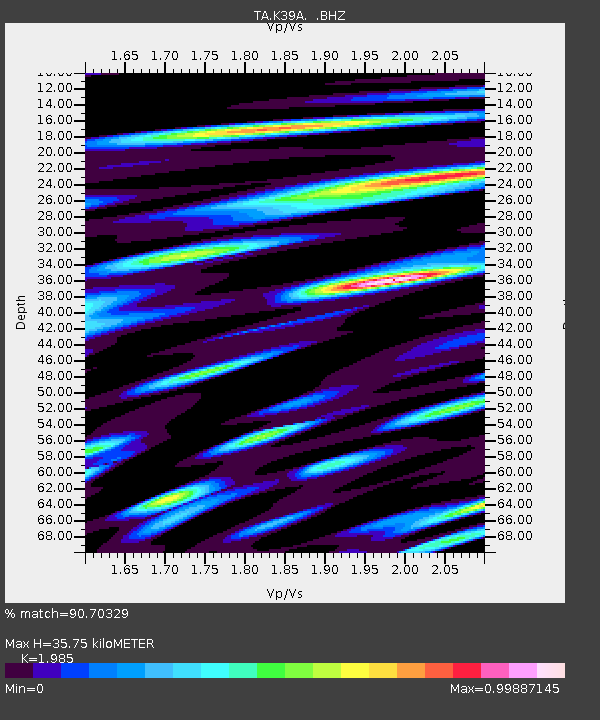
K39A Oelwein, IA, USA - Earthquake Result Viewer
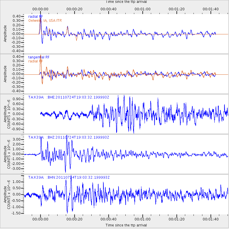
Earthquake location: Near East Coast Of Honshu, Japan
Earthquake latitude/longitude: 37.7/141.4
Earthquake time(UTC): 2011/07/24 (205) 18:51:24 GMT
Earthquake Depth: 35 km
Earthquake Magnitude: 6.3 MB, 5.9 MS, 6.3 MW, 6.3 MW
Earthquake Catalog/Contributor: WHDF/NEIC
Network: TA USArray Transportable Network (new EarthScope stations)
Station: K39A Oelwein, IA, USA
Lat/Lon: 42.71 N/91.89 W
Elevation: 332 m
Distance: 86.4 deg
Az: 36.3 deg
Baz: 320.444 deg
Ray Param: 0.044013664
Estimated Moho Depth: 35.75 km
Estimated Crust Vp/Vs: 1.99
Assumed Crust Vp: 6.53 km/s
Estimated Crust Vs: 3.29 km/s
Estimated Crust Poisson's Ratio: 0.33
Radial Match: 90.70329 %
Radial Bump: 400
Transverse Match: 84.319984 %
Transverse Bump: 400
SOD ConfigId: 405110
Insert Time: 2011-12-29 06:23:47.841 +0000
GWidth: 2.5
Max Bumps: 400
Tol: 0.001

Signal To Noise

ChannelStoNSTALTA
TA:K39A: :BHZ:20110724T19:03:32.199993Z9.9603031.244208E-61.2491667E-7
TA:K39A: :BHN:20110724T19:03:32.199993Z4.09575033.4708563E-78.4742865E-8
TA:K39A: :BHE:20110724T19:03:32.199993Z2.08355982.4127417E-71.1579901E-7
Arrivals
Ps5.5 SECOND
PpPs16 SECOND
PsPs/PpSs22 SECOND