L39A Vinton, IA, USA - Earthquake Result Viewer
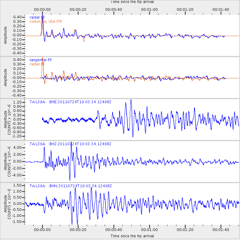
Earthquake location: Near East Coast Of Honshu, Japan
Earthquake latitude/longitude: 37.7/141.4
Earthquake time(UTC): 2011/07/24 (205) 18:51:24 GMT
Earthquake Depth: 35 km
Earthquake Magnitude: 6.3 MB, 5.9 MS, 6.3 MW, 6.3 MW
Earthquake Catalog/Contributor: WHDF/NEIC
Network: TA USArray Transportable Network (new EarthScope stations)
Station: L39A Vinton, IA, USA
Lat/Lon: 42.12 N/92.00 W
Elevation: 261 m
Distance: 86.8 deg
Az: 36.736 deg
Baz: 320.394 deg
Ray Param: 0.043724712
Estimated Moho Depth: 31.5 km
Estimated Crust Vp/Vs: 2.10
Assumed Crust Vp: 6.53 km/s
Estimated Crust Vs: 3.113 km/s
Estimated Crust Poisson's Ratio: 0.35
Radial Match: 95.86479 %
Radial Bump: 400
Transverse Match: 88.39568 %
Transverse Bump: 400
SOD ConfigId: 405110
Insert Time: 2011-12-29 06:24:00.757 +0000
GWidth: 2.5
Max Bumps: 400
Tol: 0.001

Signal To Noise

ChannelStoNSTALTA
TA:L39A: :BHZ:20110724T19:03:34.12498Z17.2325611.4555918E-68.446752E-8
TA:L39A: :BHN:20110724T19:03:34.12498Z4.04081962.912116E-77.206746E-8
TA:L39A: :BHE:20110724T19:03:34.12498Z3.38003522.8225597E-78.350681E-8
Arrivals
Ps5.4 SECOND
PpPs15 SECOND
PsPs/PpSs20 SECOND