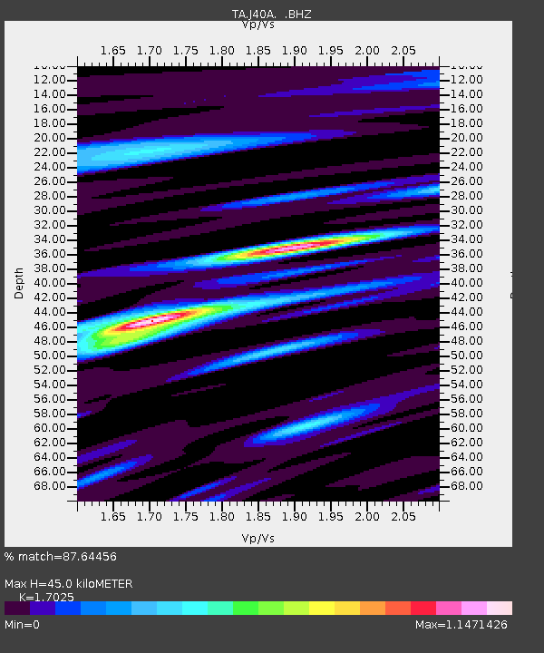
J40A Soldiers Grove, WI, USA - Earthquake Result Viewer

Earthquake location: Near East Coast Of Honshu, Japan
Earthquake latitude/longitude: 37.7/141.4
Earthquake time(UTC): 2011/07/24 (205) 18:51:24 GMT
Earthquake Depth: 35 km
Earthquake Magnitude: 6.3 MB, 5.9 MS, 6.3 MW, 6.3 MW
Earthquake Catalog/Contributor: WHDF/NEIC
Network: TA USArray Transportable Network (new EarthScope stations)
Station: J40A Soldiers Grove, WI, USA
Lat/Lon: 43.40 N/90.74 W
Elevation: 353 m
Distance: 86.4 deg
Az: 35.21 deg
Baz: 321.157 deg
Ray Param: 0.04401667
Estimated Moho Depth: 45.0 km
Estimated Crust Vp/Vs: 1.70
Assumed Crust Vp: 6.53 km/s
Estimated Crust Vs: 3.836 km/s
Estimated Crust Poisson's Ratio: 0.24
Radial Match: 87.64456 %
Radial Bump: 400
Transverse Match: 81.89018 %
Transverse Bump: 400
SOD ConfigId: 405110
Insert Time: 2011-12-29 06:24:26.845 +0000
GWidth: 2.5
Max Bumps: 400
Tol: 0.001

Signal To Noise

ChannelStoNSTALTA
TA:J40A: :BHZ:20110724T19:03:32.175029Z7.9620368.189338E-71.0285482E-7
TA:J40A: :BHN:20110724T19:03:32.175029Z2.2433341.8390557E-78.197869E-8
TA:J40A: :BHE:20110724T19:03:32.175029Z2.8198231.6984029E-76.023083E-8
Arrivals
Ps5.0 SECOND
PpPs18 SECOND
PsPs/PpSs23 SECOND