MRBL Marblemount, WA, USA - Earthquake Result Viewer
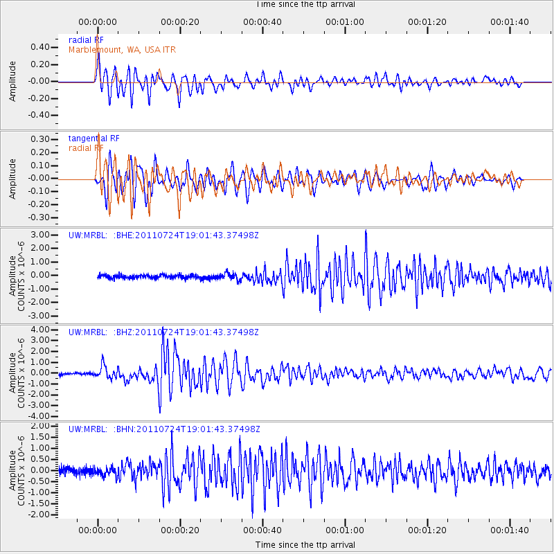
Earthquake location: Near East Coast Of Honshu, Japan
Earthquake latitude/longitude: 37.7/141.4
Earthquake time(UTC): 2011/07/24 (205) 18:51:24 GMT
Earthquake Depth: 35 km
Earthquake Magnitude: 6.3 MB, 5.9 MS, 6.3 MW, 6.3 MW
Earthquake Catalog/Contributor: WHDF/NEIC
Network: UW Pacific Northwest Regional Seismic Network
Station: MRBL Marblemount, WA, USA
Lat/Lon: 48.52 N/121.48 W
Elevation: 75 m
Distance: 67.1 deg
Az: 45.759 deg
Baz: 301.309 deg
Ray Param: 0.05714722
Estimated Moho Depth: 39.75 km
Estimated Crust Vp/Vs: 1.69
Assumed Crust Vp: 6.566 km/s
Estimated Crust Vs: 3.885 km/s
Estimated Crust Poisson's Ratio: 0.23
Radial Match: 84.44213 %
Radial Bump: 400
Transverse Match: 87.666016 %
Transverse Bump: 400
SOD ConfigId: 405110
Insert Time: 2011-12-29 06:26:16.102 +0000
GWidth: 2.5
Max Bumps: 400
Tol: 0.001

Signal To Noise

ChannelStoNSTALTA
UW:MRBL: :BHZ:20110724T19:01:43.37498Z6.18456175.868918E-79.4896265E-8
UW:MRBL: :BHN:20110724T19:01:43.37498Z1.5598121.831561E-71.17421905E-7
UW:MRBL: :BHE:20110724T19:01:43.37498Z2.14805752.568434E-71.1957007E-7
Arrivals
Ps4.4 SECOND
PpPs16 SECOND
PsPs/PpSs20 SECOND