You are here: Home > Network List > GS - US Geological Survey Networks Stations List
> Station DEC09 Decatur Surface Seismic Site, Decatur, IL, USA > Earthquake Result Viewer
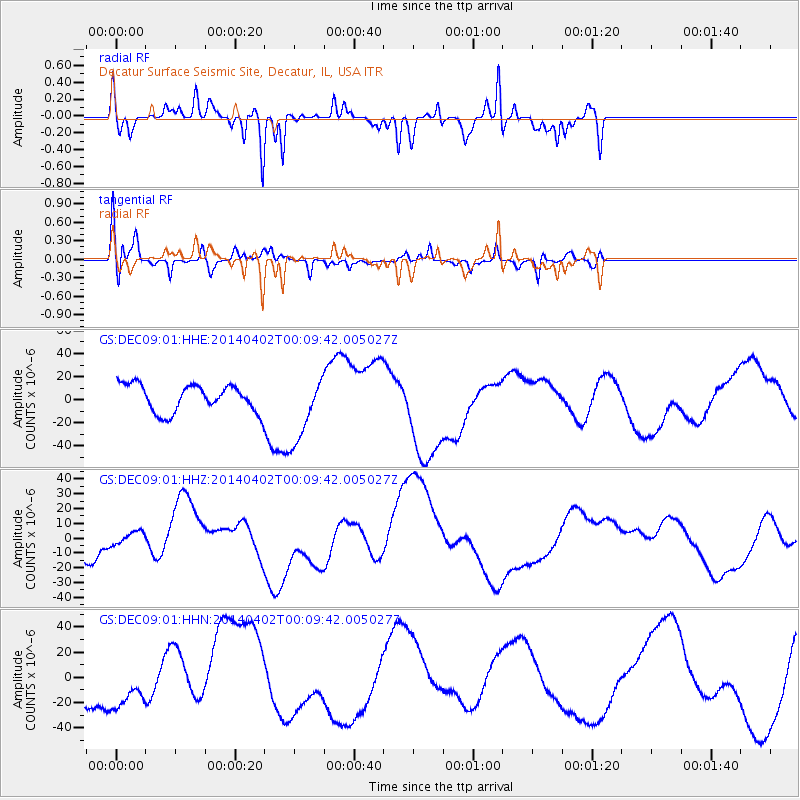
DEC09 Decatur Surface Seismic Site, Decatur, IL, USA - Earthquake Result Viewer
*The percent match for this event was below the threshold and hence no stack was calculated.
| Earthquake location: |
Near Coast Of Northern Chile |
| Earthquake latitude/longitude: |
-19.5/-70.2 |
| Earthquake time(UTC): |
2014/04/01 (091) 23:59:57 GMT |
| Earthquake Depth: |
22 km |
| Earthquake Magnitude: |
5.8 MB |
| Earthquake Catalog/Contributor: |
NEIC PDE/NEIC COMCAT |
|
| Network: |
GS US Geological Survey Networks |
| Station: |
DEC09 Decatur Surface Seismic Site, Decatur, IL, USA |
| Lat/Lon: |
39.87 N/88.92 W |
| Elevation: |
207 m |
|
| Distance: |
61.6 deg |
| Az: |
343.66 deg |
| Baz: |
159.826 deg |
| Ray Param: |
$rayparam |
*The percent match for this event was below the threshold and hence was not used in the summary stack. |
|
| Radial Match: |
52.966354 % |
| Radial Bump: |
351 |
| Transverse Match: |
59.911648 % |
| Transverse Bump: |
338 |
| SOD ConfigId: |
3390531 |
| Insert Time: |
2019-04-10 23:52:47.683 +0000 |
| GWidth: |
2.5 |
| Max Bumps: |
400 |
| Tol: |
0.001 |
|
Signal To Noise
| Channel | StoN | STA | LTA |
| GS:DEC09:01:HHZ:20140402T00:09:42.005027Z | 0.4340268 | 4.7647814E-6 | 1.097808E-5 |
| GS:DEC09:01:HHN:20140402T00:09:42.005027Z | 0.69057214 | 1.9107658E-5 | 2.7669315E-5 |
| GS:DEC09:01:HHE:20140402T00:09:42.005027Z | 2.0655415 | 2.5669571E-5 | 1.2427526E-5 |
| Arrivals |
| Ps | |
| PpPs | |
| PsPs/PpSs | |


